
Stitch Maps, to download images of Google Earth mosaic
Stitch Maps is an application that is actually for assembling image mosaics, such as scanned quadrant maps, but it also allows you to download images from Google Earth and assemble them into a mosaic that can then be saved as a single image ... good smoke because it is an executable that does not occupies settle down. I remember that a while ago I talked about an application that made Something similar, but the page disappeared ... I suppose that in something bad they walked.
Let's see how Stitch Maps works:
1. Select the image
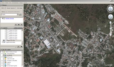
Suppose I want to download this stretch of city from Google Earth, Stitch Maps recognizes the display I have in Google Earth. Be careful, you must use the option DirectX, does not work with OpenGL.
2. Select eye height
 To do this, I select the “Google Earth” button and the system shows me the same view with a panel on the right where I can choose a height (a kind of Google aberration similar to the height of the flight), and some buttons to go down or up the height one hundred or thousand meters.
In the "settings" button I can choose where the images, compression and other tricks will be saved.
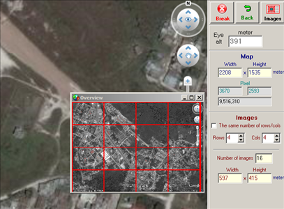
3. Display mosaic
When pressing the "maps" button, a window is displayed where the grid is reflected according to the number of rows and columns that are selected on the right. Also in the upper part you can see the height that each of the images would have, since it generates a stream for each of them... the denser the matrix, the smaller the pixel will be, therefore, the better detail (not precision).
Although it is advisable to use small areas because Google will surely ban the IP of your machine if its robots detect a massive download in a systematic way. Does it with manifold, and in two days the IP is released.
When selecting the “images” button, the si system returns a previous result of the size of the image in bmp, jpg and png formats.
I can choose to save images separately and also the pixel format between 8, 16 and 24 bits.
Then you can also automatically choose a calibration for Ozi, TTQV, GPS Track, Global Mapper, Fugawi, World-file, Mapinfo and GPSdash2.
4. Run image capture
When selecting the “scan” option, it starts to create the captures, showing the ones that are being captured in blue... at this time it is not recommended to browse the Internet or other applications because it apparently interferes with the stream.
5. Save the image.
At the end, the image appears, which can be edited by assigning it a rotation or cutting the edges, since the Google Earth controls appear on the right and the watermark of the image provider appears below. A simple crop and it's ready to save.
 The image is saved without georeference, but for this it is the calibration file, which is saved for any of these formats. In this, the control point numbers, latitude, longitude and pixel matrix are identified, note that the first two and the last two are the four corners of the image.
They can also see that the image is not a square by seeing the coordinates that follow a curvature. This requires calibration.
The trial version can be downloaded, does everything but save the images.
The paid version of Stitch Maps goes for $ 48 ... not bad because you can buy it via Paypal ... especially now that manifold can no longer stick to Google.
In this post some are explained common problems by Stitchmaps.
In this link you can busit Stitchmpas from Shareit!, although it does not appear for test download; you would have to try if you can actually make the purchase.


Try a smaller area if you see the file is created. It's possible that the area selected is so big, that the memory of the computer can't create that.
hi ihave a problem for use stitch map. the end of save the image it can be Diagnosis the Mosaics. please guide me
HOW TO DOWNLOAD VIDEOS
Negative. Stitchmaps license is no longer in place.
Happy those who bought it and invested the 49 dollars that it was worth.
Something similar can be done with PlexEarth, although not with the same simplicity
I also need to buy the license, but I can not find it anywhere, someone who knows where to buy it, please.
Thank you
I can help you with this problem of outdated images. My mail is not but I point it here, mdangel21@HOTMAIL.com
Ericson: Stitchmaps is no longer available, unfortunately.
Agustin: Wait sitting down, because the same coverage strip I'm waiting for
Where can I buy the software license, I have been looking for and have not found, please someone who can facilitate it?
Waiting for Google to do a map update sweep through the Ojos de Agua area, Comayagua ... the current maps are unusable ...
Hello, I'm looking for soft but the link is damaged, someone who can pass it on to me ... it would be much appreciated ...
And how far is the gap?
Guys, because I was working on Stitch Maps, but I let it do it now the images are out of date, and I have looked everywhere for the problem I see that another also has it but I do not see solutions, I have modified everything, even download other versions of google and Stitch Maps ... someone knows what waves
Your connection is too slow. Remember that Stitchmaps captures your screen, so you will capture what you find, if there is a window, if you have another program open clogging in the middle of the screen, it will capture it.
Moves every window even from stitchmaps out of the catch.
I have used stichmap for the first time and followed the steps that have been indicated both on this page and in others where it is commented.
However in the end when I save the image I get a GREEN adventure.
I have tried to download a 6 × 6 image, it has come to weigh up to 50 Mb.
Set the stich as suggested, I saved the calibration and when everything poarecer to go well I get that green image as if I had not captured anything.
The green image contains the entire outline of the area that I have visualized in the 36 image downloads that you have supposedly done. Inside each rectangle appears a message “Loading Googloe Earth” (this message is repeated in each of the shots, that is 36 times).
Please I need help to solve this problem
hi, i can't download stitchmap… can someone help me?
Yes, as far as I can see, the page is in private mode. But the software can still be bought with Shareit.
Thank you. I actually got it for Share it. But I had to claim that they enabled the link that they provided.
I think it's just under maintenance.
You can also buy it through Share it!
https://secure.shareit.com/shareit/product.html?productid=300170740&sessionid=1734654921&random=5b2e1f91b75d9520dacf91d196d9a418
The website does not exist anymore. Another way to get the program and the license?
Thank you
Hi, Henri. As I mentioned earlier, StitchMaps is worth $ 48, the save image option can only be done when buying the license.
I perform all the steps indicated in your help, but in the end, after performing the SCAN, does not activate the SAVE option.
Any Suggestions?