
gps
-
Geospatial - GIS

Geomoments - Emotions and Location in a single app
What is Geomoments? The fourth industrial revolution has filled us with great technological advances and the integration of tools and solutions to achieve a more dynamic and intuitive space for the inhabitant. We know that all mobile devices (phones…
Read More » -
Engineering

101st century cities: infrastructure construction XNUMX
Infrastructure is a common need today. We often think of smart or digital cities in the context of large cities with many inhabitants and a lot of activity associated with large cities. However, small places also need infrastructure. Factorize…
Read More » -
Downloads

6 geo-engineering publications for free download
Today we will present you ebooks and publications to understand the technological advance in the field of geo-engineering and its impact on everyday life. All options completely free and easy to obtain. Faced with the dizzying growth of technology...
Read More » -
GPS / Equipment

TopView - Application for surveying and topographic stakeout
Every day we see that our needs are changing and that for different reasons we are forced to acquire different PC Software, GPS, and Total Stations, each one with a different program, with the need for learning for each…
Read More » -
Google earth / maps

Download maps and plan a route using BBBike
BBBike is an application whose main objective is to provide a route planner to travel, using a bicycle, through a city and its surroundings. How do we create our route planner? Indeed, if we enter your website, the first thing that…
Read More » -
Geospatial - GIS

Geospatial technology, its role and importance within the IT structure in Transportation Departments.
geospatial technology. Conceived as all the technology used to acquire, manage, analyze, visualize and disseminate both data and information related to the location of an object, it has transcended its initial conception of a triad composed essentially of GIS, GPS...
Read More » -
Geospatial - GIS

The intrinsic georeference
When we read the different theories that support the communication that cartography entails, both as a science to represent geographic phenomena, and as an art to give this information the necessary aesthetics, we realize that the moment in which we live…
Read More » -
Geospatial - GIS

Product Comparison Section
Geo-matching concentrates all the review value of GIM International and Hydro International products in one place. Geo-matching.com is an independent product comparison website for hardware and software professionals in the field of…
Read More » -
GPS / Equipment

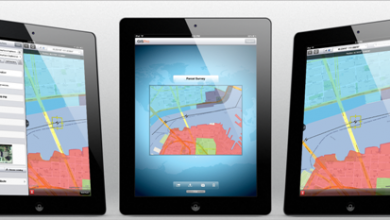
Get submeter accuracy from an iPad / iPhone
The GPS receiver of an iOS device, such as an iPad or iPhone, obtains accuracies in the order of any other navigator: between 2 and 3 meters. Apart from GIS Kit, we had seen few other possibilities to improve its precision, however…
Read More » -
Featured

Drones for Professional Civil use, photogrammetry in minutes.
Knowing how autonomous units work today gives us the satisfaction of having known the origin of things but also taking advantage of new advances. It happens for those of us who knew the traditional methods of photogrammetry, and their terrible…
Read More » -
Apple - Mac
GIS Pro The best GIS application for iPad?
Last week I was talking with a Canadian friend who was telling me about the experience they have had using GIS Pro in cadastral survey processes. We have almost come to the conclusion that although there are other tools, from what…
Read More » -
Google earth / maps

OkMap, best for creating and editing GPS maps. GRATUITOUS
OkMap is perhaps one of the most robust programs for building, editing and managing GPS maps. And its most important attribute: It's Free. We have all seen ourselves at some point in the need to configure a map, georeference a…
Read More » -
GPS / Equipment

GPS Comparison - Leica, Magellan, Trimble and Topcon
It is common, when buying a topography equipment, it is required to make a comparison of GPS, total stations, software, etc. Geo-matching.com is designed just for that. Geo-matching is a site of Geomares, the same company…
Read More » -
Cadastre

The Topographic Engineering in the development of the countries of America
This is the name of the First Ibero-American Congress of Topographical, Geodetic and Geomatics Engineering that will take place in Jalisco, Mexico. The event is being promoted by 11 Mexican Associations of Topographical Engineers, and will be from 16 to 18…
Read More » -
GPS / Equipment

GPS on Android, SuperSurv is a great alternative GIS
SuperSurv is a tool specially developed for GPS on Android, as an application that integrates GIS functionalities with which data can be collected in the field efficiently and economically. GPS on Android The latest version, SuperSurv 3…
Read More » -
Geospatial - GIS

3 Magazines and 5 experiences of the geomatic field
It's time to review some magazines whose recent editions have come out; here I leave you at least interesting experiences that come out in the latest edition of these magazines. Geoinformatics 1. User experiences in the use of GIS Software…
Read More » -
GPS / Equipment

What are Bentley and Trimble up to?
This looks like my April Fool's Day predictions, but it's not. A few hours ago a collaboration agreement was formally communicated about which we heard something behind the scenes, and that leaves us thinking...
Read More » -
GPS / Equipment

Comparison table of almost 50 total stations
GeoInformatics has surprised us this month with an edition that shows 49 different total stations in a comparative table that can be very useful for those who need to make a decision at the time of a purchase, as well as…
Read More »