
How to enter coordinates in Google Earth / maps
If you want to enter a specific coordinate in Google Maps or Google Earth, you only need to type it in the search engine, with certain rules to respect. It is a very practical way out in case you want to send someone by chat or email a coordinate that we want them to view.
The nomenclature of degrees
Google Earth uses latlong-type angular format coordinate systems, so they are required to be written in this form in the order “latitude, longitude”.
In the case of latitudes for the northern hemisphere, it will be necessary to write it in positive, in negative for the southern hemisphere. In the case of latitudes, for the eastern hemisphere (from Greenwich to Asia) it will be positive and for the west, that is, to America it will be negative.
 In case of Google Earth, it is written in the left bar, it is written down and then click on search
In case of Google Maps, in the upper left search engine, and then the "search" button is pressed as shown in the following examples.
1. Coordinates in degrees, minutes and seconds(DMS): 41°24’12.2″N 2°10’26.5″E
In this case, the decimals must be in the seconds and the degrees must be rounded.

It means that that coordinate is 41 degrees above the equator, because it is positive and 2 degrees east of Greenwich, because it is positive. A common mistake is the minute symbol, you should use ('), often people confuse it with the apostrophe and get an error (´).
In case you have trouble finding the symbol, what you can do is copy paste from this address 41 ° 24'12.2 "N 2 ° 10'26.5" E and just change the data.
2. Coordinates in degrees and minutes (DMM): 41 24.2028, 2 10.4418
The degrees are rounded and the minutes include the decimals that the seconds would take. As you can see, the same coordinate is reflected at the bottom only in degrees.

3. Coordinates in decimal degrees without minutes or seconds (DD): 41.40338, 2.17403
In this case there are only degrees and it is the most used type lat / lon style and as you can see, always in the upper bar the coordinate in graods, minutes and seconds is maintained.

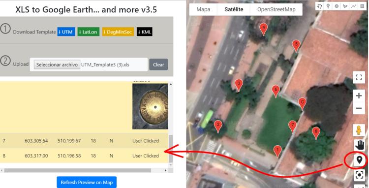
4. UTM coordinates in Google Maps
For UTM coordinates there is no functionality in Google Maps that allows entering the coordinates. You can do that with an Excel template and drag them as shown in the following application.
[advanced_iframe src=”https://www.geofumadas.com/coordinates/” width=”100%” height=”600″] Step 1. Download the data feed template. Although the article focuses on UTM coordinates, the application has latitude and longitude templates with decimal degrees, as well as in degrees, minutes and seconds format.
Step 2. Upload the template. By selecting the template with the data, the system will alert if there was data that could not be validated; Among these validations includes:
- If the coordinate columns are empty
- If the coordinates have non-numeric fields
- If the zones are not between the 1 and the 60
- If the hemisphere field there is something different than North or South.
In the case of latlong coordinates, it is valid that the latitudes do not exceed 90 degrees or that longitudes exceed 180.
The description data supports html content, like the one shown in the example that includes the display of an image. It would still support things like links to routes on the Internet or the local disk of the computer, videos, or any rich content.
Step 3. Visualize the data in the table and on the map.
Immediately the data is uploaded, the table will show the alphanumeric data and the map the geographical locations; As you can see, the upload process includes the transformation of these coordinates into geographic format as required by Google Maps.

Dragging the icon on the map you can have a preview of street views or 360 views uploaded by users.

Once the icon is released, the points placed on the Google Street View can be viewed and navigated over it. By clicking on the icons you can see the details.

Step 4. Get map coordinates. Points can be added to an empty table or to one uploaded from Excel; the coordinates will be displayed based on that template, auto-numbering the label column and adding in the detail that was obtained from the map.
Here you can see the template working in video.
Download the Kml map or the table in excel using the gTools service.
You enter a download code and then you have the file that you can view in Google Earth or any GIS program; The application shows where to obtain a download code with which you can download up to 400 times, with no limit to how many vertices there can be in each download using the gTools API. Just the map shows the coordinates from Gooogle Earth, with the three-dimensional model views activated.
In addition to kml you can also download to excel format in UTM, latitude / longitude in decimals, degrees / minutes / seconds and even dxf to open it with AutoCAD or Microstation.

In the following video you can see how the data and other features of the application are downloaded.
Here you can see this service in full page.


You have to know the reference of those coordinates. Apparently they are UTM, but you need to know the area and the reference datum, to do the UTM conversion to degrees.
how to pass co-ordinates of decimals to degree, eg of coordinates point #1 this 1105889.92 north 1197963.92.
point # 2 this 1106168.21 north 1198330.14.
Good night, I would like to georeference flat coordinates to google maps, ahem East 922933 and north 1183573 I always have difficulty converting them to longitude and latitude because I georeference in areas that have nothing to do with what I worked on ... thank you very much
Because that's how the UTM system works. Each zone contains 6 degrees of length, but since they are projected units, they all have a meridian at the center with X = 500,000 and thus they increase towards the right, until they reach the next zone. Also to the left it decreases until the end of the zone.
Review this post.
http://www.geofumadas.com/entendiendo-la-proyeccin-utm/
I forgot:
In the CAD the grid goes like this (from West to East):
188000
184000
180000
176000
172000
.
.
.
Thanks again.
Goodnight.
I wanted to make an appointment:
Why, when I go from zone 18L to 17L, do the coordinates "restart" again at a fairly high value (to decrease as I continue to get closer to the east)? Working with UTM Coordinates, of course.
What happens is that I have a hydrographic basin in CAD, in which I want to locate pluviometric stations, the problem starts because the CAD is with UTM coordinates and these are running, that is, they do not do the "reset" that I mentioned in the previous paragraph.
I think this will be better understood:
Safuna Station: 210300.37 m. E. - Zone 18L
Corongo Station: 180717.63 m. E. - Zone 18L
Cabana Station: 829 072.00 m. E. - Zone 17L
Rinconada Station: 767576.77 m. E. - Zone 17L
Hopefully they can help me, since I need it enough.
Thank you.
Google maps asks for a specific data format to find a place. first Latitude for example: 3.405739 (note, it is a point and not a comma) and longitude -76.538381. If the latitude is in the north it will be positive, that is, above the equator, if the longitude is west of the zero meridian or Greenwch, as in this case, it will be negative and both parameters are separated by a comma with no spaces in front or behind. of the numbers because the spaces are taken as part of the coordinates and of course it does not find the place. At the end it should be “3.40573,-76.538381” and then Enter. The quotes are to denote the data that must be entered, they should not be included.
Convert them to geographical, in combinations X, Y for example 497523.180,2133284.270
Hello, good morning, I need to locate a lot. I just have these cordenadas. I hope and can help.
497523.180 X 497546 .300 X 457546.480 X 497523.370 AND 2133284.270 Y2133284.310 AND 2133180.390 Y2133180.340 many thanks I hope and can help me
Clear is very simple for this follows the following steps:
take the keyboard
put it on the alphanumeric keyboard and go ahead my friend
ready!!
good morning, sorry you could help me with these coordinates 526.437,86 (longitude) 9.759.175,68 (latitude), I do not know how to enter this data in google earth.
thanks in advance
Male Q
good afternoon :
my drawback is that I have utm units and I need to convert them to decimal degrees, which is the only unit that accepts google earth.
enter tools, in the lat long box but does not vary only accepts decimal degrees
and you can locate the area, entering the menu tools >> options
in the view tab 3d, there is a group box that says to show lat / long, you click on the radius universal buton mercator and you accept.
there will be a grid of all the world, in the x axis are the numbers, and in axis and are the letters, ejm, peru is in the 17M, 18M, 19M, 17L, 18L, 19L, 18K and 19K zones.
I hope you serve
Hello Nadres.
That coordinate is repeated in each of the 60 UTM zones that divides the world, as well as in the northern and southern hemispheres.
You need to know the area and hemisphere.
GoogleEarth displays the coordinates in WGS84 datum. But there are many other datum, so you should ask the question.
If you do not know and prefer to venture ...
1 In google Earth, go to configuration and enable coordinates, Universal Traverso Mercator. Activate the option to see a reticle.
2. There you can see the zones, I suppose you know in which country you expect to find that location. You already have the zone, and if your point is above the equator then your hemisphere is north.
3 With the Google Earth tool to place points, you place a point in any place, and in the panel that is shown you change the coordinates, indicating where you are looking and selecting the zone and hemisphere that you detected in the previous step.
I need to locate in Google Earth these coordinates in utm 6602373 north, this 304892 and I do not know how! help me!!!!
Insert a point in Google Eart, then touch it and you see the properties. There you change the coordinate in the UTM tab. But you need to know the Zone, because the coordinate is repeated in each of the 60 zones of the world.
Hello, I want to locate this point in Google Earth. Can not you help me or how do I get them?
498104.902,2805925.742
Thank you
Apparently it is a survey in which relative coordinates were used, for example it started from a point called 5,000.00 to have no negative values.
The coordinate should be:
10568.33,10853.59
using as decimal separator the period and the comma as separator of the list
If what you have is AutoCAD, then you do:
Command point, enter
write the coordinate, enter
command point, enter
you write the coordinate ... etc.
Another option is to concatenate them in Excel so that they are not being written one by one
Hi. I would like you to help me in this little problem that I am having, I have a map of my field and it has these coordinates.
vert xy
1 10.568.33 10.853.59
I want to mark the perimeter of the field.
Hi. Your coordinates correspond to the Regional Museum of Ica, in Jr Junin near the junction with the Jr Pisco. I hope I've helped. Greetings.
Si
can google earth locate me with coordinates north and east in the system of coordinates utm because since in universal coordinates it appears with coordinates utm
How do I enter a point in the Google Map ??? and that does not appear on the map, I would like to enter it.
You only write it in Google Earth
-14.0681, -75.7256
I want you to help me as I locate an address or give me a reference to which part of ica corresponds latitude -14.0681 length -75.7256
I would greatly appreciate your help
Hello Romina, Google Earth allows you to import the vertices with the coordinates you have. But you can not ask him to draw you the polygons.
There the option may be that you import the vertices and then draw them directly in Google Earth.
Or that you do everything in AutoCAD and then export to kml, which could be easier because there you can have the vertices imported and the properties drawn once.
Hey.
I have a series of coordinates (latitude and longitude) in excel, and I need to generate polygons (the coordinates that I have in excel are the vertices of the polygons that I need to make). I wanted to know if I can import those coordinates to google earth from excel and tell it to draw the polygons based on those coordinates. Until now I was drawing the polygons and running the vertices "by hand".
Thank you very much!
You are using the inappropriate symbol for minutes, and you also have it after the 33 grades. It should work like this:
33 ° 05'50.44 s, 71 ° 39'47.57 w
the symbol ´ than ′ and that 'is not the same
How would this be?
33 ° ´05´ 50.44 S - 71 ° 39´ 47. 57 w
It does not work for me.
no alternative works….
10 ° 40'42 n, 72 ° 32'3 w
A coordinate of metric system could not be entered, since it repeats the same in each zone and in each hemisphere, that is, 120 times exists the same coordinate.
It would be interesting to enter coordinates into units of the metric system.
North 10 degrees, 40 minutes, 42 seconds, West 72 degrees, 32 minutes, 03 seconds
Do you know what this cordenada would look like?
Thank you!
Hi harry, that works for both images and vectors.
What you have are control points and objects that you want to adjust based on those points.
So just activate the command, then you go one by one placing the point to move and the reference point.
Then, you enter, you select the objects to be adjusted and then the modification is done.
Check out this post
Good morning, I'd like to know if anyone knows how to georeference an image of
Google Earth in the maps menu, tools, rubber sheet
hehehehe it was "you saved" the same thanks
You passed me you left a thank you