
Diagnosis on the situation of the Territorial Administration System in Ibero-America (DISATI)
Currently, the Polytechnic University of Valencia is developing a diagnosis of the current situation in Latin America regarding the territorial administration system (SAT). From this it is intended to identify needs and propose advances in cartographic aspects that allow strengthening the different territorial administration systems in Ibero-America. All of this, with the collaboration of international and Ibero-American groups that represent the vast majority of territorial administration systems in different countries and institutions. The information that the members of these groups can provide is essential to obtain previous results, evidence, and current needs, which contribute to determining the current situation of the systems. And from there, identify where actions should be directed to improve them.
This is a project executed by Cartographic Coordination in the Territorial Administration System (CCASAT), a group based at the Polytechnic University of Valencia (UPV), Spain; in the Department of Cartographic Engineering, Geodesy and Photogrammetry (DICGF) and in the Higher Technical School of Geodetic, Cartographic and Topographic Engineering (ETSIGCT).

The DISATI Diagnosis is a project derived from the objectives of the CCASAT, which is to promote support, collaboration and research in all those areas related to cartographic information that allows effective administration of the territory (such as cadastral information, and/or registration information, or similar), and fundamentally in aspects that serve as support to achieve security in land tenure and valuation with administrative effect. Promoting the dissemination, transfer of knowledge, research, coordination, consulting and optimization of resources.
In particular, the DISATI diagnosis seems to me to be an invaluable and timely initiative in light of the modernization processes that are currently being developed in Latin America. About this, CCASAT will publish a publication.
The concept of Territory Administration System (SAT) – It is a current issue and seeking to diagnose it at the Latin American level can lead to some difficulties.
In an interview held with two doctors from the University, we initially reflected on some comparative aspects of this Western context. Although the CCASAT diagnosis focuses on Ibero-America, along the way we talked about those “small differences” with other European countries, where visions of the continental model were not inherited, which today reflect disparate results in terms of the efficiency of the SAT with a focus to the citizen.
Such is the case of the Nordic countries, where according to the Doing Business study, a registration that in Norway It takes 3 days with a single intermediary, . This same process takes 13 days, going through 6 intermediaries and In colombia It would be 64 days with 7 intermediations… if you are lucky the first time.
In the interview I shared with them about the lack of a model that can define a common scope, a value chain and a roadmap that can characterize objectively measurable indicators. Just define the scope of what the words in the acronym mean SAT (System – Administration – Territory) raises many questions that could look different in each context.
I leave here some reflections, which are not part of the interview held for the DISATI diagnosis.
1. SAT for what?
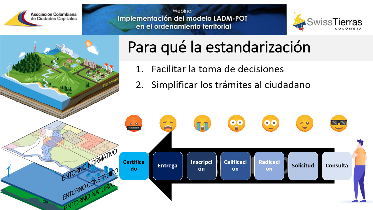
The definition of “What the system is for” is vital when carrying out modernization processes, not to mention when making comparisons. If your focus is on improving decision-making, we could only think about the needs of the official that can be resolved by having information and regulations; But if we consider that it is also for the reason for being of the public service, we would have to think about improving the operation of the processes, procedures and services for the citizen. Such as the reduction of times, costs, intermediations and improvement of the registration infrastructure.
The following image, taken from a SwissTierras presentation about the importance of what is done for a SAT. Whether it is simplifying, applying technology, updating data, updating policy, you must be clear about why.
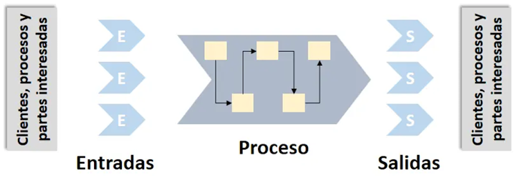
2. SYSTEM – Does the SAT include systems theory for an integrated management approach in line with ISO 9001?
If so, what processes, for which interested parties, only cadastre, does it include registration, does it include regularization or social organization of property, does it include territorial planning, does it include construction information management, does it include infrastructure information management?
And the questions are necessary, because the unhealthy tendency of Latin America to make the modernization of the SAT more complex may end up being another mess than the one that already existed. The example of the northern European countries shows that it is not about integrating thousands of actors, but about making this entire operation easy in fewer procedures, fewer systems, less data.
The clearest example in Latin America where the cadastre is a social priority is the phrase “let's remove the notary from the transactional chain.” The peace agreement to carry out the cadastre could end and begin a new, much more catastrophic war.
In most developed countries in northern Europe, if the data in the system meets the quality requirements, the notary is not necessary... and in better scenarios, neither a curator, nor the registrar with his retinue of qualifiers, amanuensis.
If the operation processes are not included, the SAT should be seen almost as a computer ecosystem that serves as a Land Information System or a Territorial Information System. But from the moment we use “Management System”, it is necessary to consider the operation processes that convert information inputs, plus policies, plus tools, into outputs of information products and services in a cycle of feedback loops. .
Hence interesting good practices of modernization projects such as the Integrated Cadastre – Registry Management Model (MGICR) of Nicaragua, which worked hard to optimize processes and procedures so that the system responded to these improvement scenarios. This is not a field for cartographers or topographers, but rather a field of industrial engineering applied to public service, from which a SAT could rescue key aspects for comparison purposes.
3. TERRITORY – Is the SAT consistent with the 2014 / 2034 Cadastre declarations?
This vision raises integrated management trends, in aspects such as continuity in information on private law, public law and, above all, the modeling of legal territorial objects of an SDI, which produce Rights, Restrictions and Responsibilities (RRR). Delimiting whether the SAT includes this will involve comparing interoperability issues with information such as risks, protected environmental borders, spatialized territorial planning decisions in two and even three dimensions.
If the SAT does not include other territorial objects and is only measuring cadastral and registered properties, valued and available in a geoportal... it is valid. But then I don't know if we should call it “Territorial Administration System”.
Also of good global practices, consensus and the philosophical heritage of Cadastre 2014 / 2034 Information standardization models are born, such as the case of ISO-19152:2012 (LADM). If this aspect had to be considered as a measurement element, levels of compliance with the standard or its equivalent would have to be considered, with respect to indicators such as the versioning and spatialization of rights, restrictions and responsibilities. This taking into account the LADM I version that focuses on Cadastre – Registry, in the future it would be necessary to consider the versions that the FIG has under discussion: LADM II, III, IV focused on standardizing other realities in space and time, such as valuation, maritime territory and territorial planning.

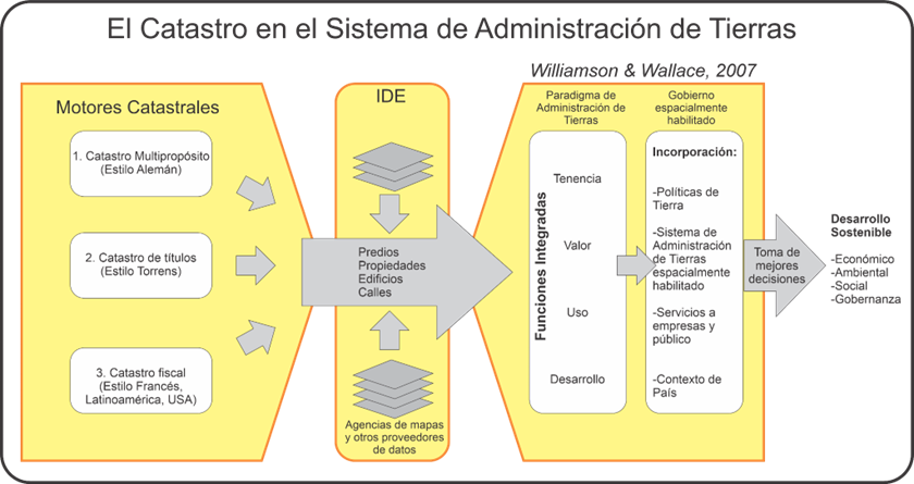
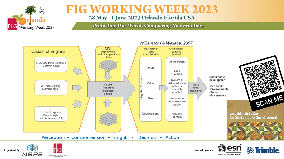
In the graph, one of the FIG presentations, in which SAT functions are related to future versions of the LADM standard. The functions include the decomposition into valuation, registration, infrastructure/services and territorial planning; which in a certain way are the “facts” version of the four functions, while the actions in the use of these facts lead to the management of taxes, regularization, development planning and management of natural resources. Very logically, pieces of the multipurpose cadastre that we proposed in Geofumadas 2007.
4. ADMINISTRATION SYSTEM – What is administered in the SAT?
A comparison model is necessary to be fair and objective. From its acronym in English “Land Administration Systems”, just giving an example of what is related to the term “LAND” – which for Anglo-Saxons could be simple -, it would be something complicated for a Latin America with diverse legislation.
If we submit it to a table of conceptualization gurus, where we had an Argentinian, a Mexican and a Central American... it would be endless days between the law, the sketches, the blackboard... the beers and marijuana just to define soil, land and territory.
Meanwhile, the citizen is waiting for his property title... for it to at least reach the hands of his grandson... preferably, in this life.
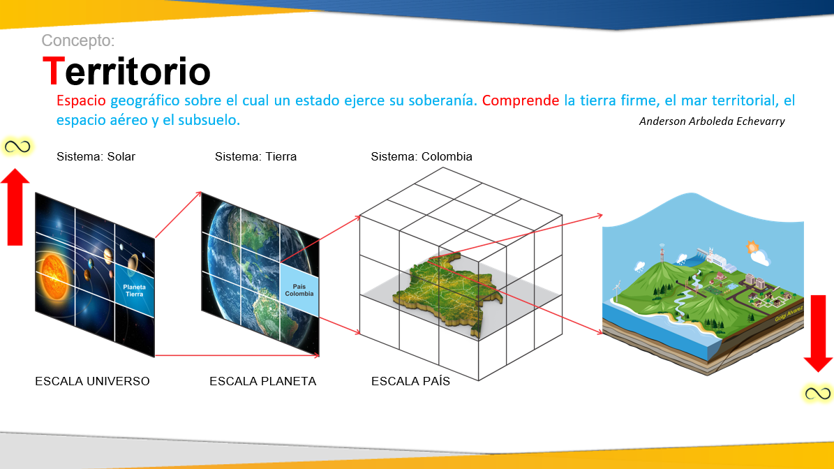
I understand that for other issues the systemic scope of what is managed might not be important. But if it is a question of considering the systemic vision of the territory at the country level, surely we must be clear that we are not referring to a mere cadastral inventory in the style of the 1980s. From one of my latest presentations, I rescue this example of the systemic scope, in which from the largest (galaxies and universes) to the smallest (molecules and subatomic particles), defining the scope of the system is important to measure what is we intend to manage.
Defining the scope of the SAT is important, not so much because it could have very few things... but because the complexity gurus could want us to include the measurement of space - time in units of energy and matter. XD
5. TERRITORY ADMINISTRATION – Is it consistent with existing models for sustainable development?
One of the existing models is the “LAS for development” by Willamson & Wallace, which has already been disseminated several times in spaces such as the FIG and even ESRI promotes it as a guiding document in its Esri Press portfolio. This model presents a vision of information inputs and decision outputs, and although graphically it gives the impression of being an “information system”, it includes a multipurpose “for sustainable development”, with four functions that beyond tenure and The evaluation includes use and development.
The model falls short in the graphical ability of how policies and tools come into play. However, it is a good example of systemic vision. If a SAT had to be measured with a model like this, it would have to be clear how far these functions go; as well as not only measuring whether all the pieces of the machinery exist but also whether they have an associated quality model to ensure that they are fulfilling their purpose in an optimal manner.
In the graph of one of FIG's presentations, on the SAT model for sustainable development. Something interesting about this model is that by breaking it down, we could perfectly have, on the left, the reality of the territory, in the center, following the arrow, the digital twin of information management and on the right the digital twin of the operation. It is clear that the challenge is in this feature integration, because they are not isolated or independent processes.
This is a good example of the need for a model and boundary between land and territory in relation to SAT with a sustainable development approach, if we compare it with the SAT from the perspective of FAO, which literally says:
Land Administration System (SAT). It is the State system, based on a legal framework, which administers, through its different institutions, the management of information and property rights policies. This establishes the administrative and judicial procedures for the transfer, physical attributes of territoriality, uses, valuation of the land and tax burdens, which will provide security and legal certainty in matters of property.
You can see that this scope is almost about the tenure and value functions. Does not include use or development.
As an exercise on this article, if we could compare some SATs in Latin America that have been in the process of modernization, at basic levels of strengths and weaknesses with respect to the functions of the SAT model for the development of Williamsom, we would have the following comparison at a quick glance. :
SAT Colombia.
Strengths:
- FUNCTIONS TENURE, VALUE, USE AND DEVELOPMENT: It has a comprehensive long-term model within the framework of the SAT Territory Administration System. The conceptualization of Colombia's SAT is largely based on Williamsom's model.
- FUNCTIONS TENURE, VALUE, USE AND DEVELOPMENT: Includes a vision of integration of the Cadastre, Registry, Regularization and territorial objects of territorial planning that cause RRR, both in the SAT regulations and the IDE and the National Statistical System.
- FUNCTIONS TENURE, VALUE, USE AND DEVELOPMENT: It has a broad legal framework that defines the roles within the SAT framework of institutional, municipal and private sector actors.
- FUNCTIONS TENURE, VALUE, USE AND DEVELOPMENT: Methodological and regulatory adoption of the ISO 1915212 standard for Cadastre, Registry and other territorial objects that constitute RRR.
- TENURE FUNCTION: Solid governance of the Registries and Notaries through a superintendency.
- TENURE AND VALUE FUNCTION: Solid governance of the cadastral authority (IGAC) and delegated actors such as Cadastral Managers and Cadastral Operators.
- FUNCTIONS TENURE, VALUE, USE AND DEVELOPMENT: Advanced modernization progress of the Colombian ICDE Spatial Data Infrastructure.
Weaknesses:
- FUNCTIONS TENURE, VALUE, USE AND DEVELOPMENT: Although there is a marked continuity in the multipurpose cadastre policy, the high level of outdated cadastral information and cartography of territorial objects that constitute RRR is critical.
- FUNCTIONS TENURE, VALUE, USE AND DEVELOPMENT: Low level of simplification of procedures and procedures related to cadastral updating, regularization, registry registration, updating of cartographic information that constitutes RRR.
- FUNCTIONS TENURE, VALUE, USE AND DEVELOPMENT: Complexity of governance of processes and systems that manage cadastral, registry and territorial object information that constitute RRR.
- TENURE FUNCTION and VALUE. Little clarity of the active participation role of municipalities and cadastral managers in permanent cadastral updating in aspects such as informality.
SAT Honduras.
Strengths:
- FUNCTIONS TENURE, VALUE, USE AND DEVELOPMENT: It has a comprehensive long-term model with the National Property Administration System SINAP, which includes subsystems such as the Unified Registry System (SURE), the National Territorial Information System (SINIT), the Registry of Territorial Planning Regulations (RENOT), and the National Spatial Data Infrastructure (INDES).
- TENURE FUNCTION: Roadmap to simplify and unify Property Registries in SURE, example: Cadastral Registry, Real Estate, Vehicle Property, Commercial Property, Intellectual Property.
- TENURE FUNCTION: Solid governance of the main land administration actors linked to SURE, in a single institution: Property Institute, which includes Cadastre, Registry, Geography and Property Regularization.
- TENURE FUNCTION: Solid participation model in the SURE Unified Registry System, with actors such as the National Cadastre, Real Estate Registry, Chamber of Commerce, Municipalities, Banking Sector.
- TENURE FUNCTION: Adoption in practice of ISO 19152 (LADM) at the SURE system level for cadastral information.
- TENURE FUNCTION: Decentralization of municipal cadastral management under the regulations of the national cadastre and delegation of participation in the update as an associated center.
- VALUE FUNCTION: Decentralization to the municipalities of the valuation and collection from the cadastre.
Weaknesses:
● FUNCTIONS USE and DEVELOPMENT: Of the main SAT systems, only SURE has a high degree of maturity (20 years). SINIT, RENOT and INDES have a low level of implementation and governance.
● FUNCTIONS USE and DEVELOPMENT: Lack of modernization of the spatial data infrastructure and disengagement from the National Statistical System.
● FUNCTIONS OWNERSHIP, VALUE, USE and DEVELOPMENT: Low level of adoption of standards and good practices of the IGIF methodology for information for cartography.
● TENURE FUNCTION: Incipient level of integration of actors external to cadastral and registry management, such as topography/surveying professionals, as well as notaries.
● VALUE FUNCTION: Lack of integration of information related to real estate valuation, which is only part of municipal management, but is not linked to an observatory or national system.
SAT Nicaragua.
Strengths:
- TENURE AND USE FUNCTIONS: It has a partially comprehensive long-term model within the framework of the Comprehensive Cadastre and Registry Management Model, which includes subsystems such as the Integrated Cadastral and Registry Information System (SIICAR), Spatial Data Infrastructure of the National Institute of Territorial Studies (IDE-INETER) with first but solid steps in the IGIF methodology.
- TENURE FUNCTION: Roadmap to simplify and unify Property Registries in SIICAR, example: Cadastral Registry, Real Estate, Movable Guarantees, Commercial Property.
- TENURE FUNCTION: High degree of consolidation of the governance of the main land administration processes and actors linked to SIICAR, which includes Cadastre, Registry, Geography and Property Regularization.
- TENURE FUNCTION: Solid and with growing implementation of the participants of the SIICAR System, with actors such as the National Cadastre, Real Estate Registry, Attorney General's Office, Surveying Professionals, Notarial Professionals.
- TENURE FUNCTION: Adoption in practice of ISO 19152 (LADM) in the SIICAR system for cadastral information.
- TENURE AND USE FUNCTION: In the process of implementation and adoption of standards by the Spatial Data Infrastructure.
Weaknesses:
- VALUE AND DEVELOPMENT FUNCTIONS: Of the main SAT systems, only SIICAR and the cadastral IDE have a moderate degree of maturity (more than 10 years) in the TENURE and USE functions, with not optimal integration conditions. There is a limited degree of integration between the other systems related to the SAT.
- FUNCTIONS USE and DEVELOPMENT: Limited degree of modernization of the spatial data infrastructure and decoupling and still incipient integration route to other systems.
- TENURE FUNCTION: Limited clarity of the participation of the municipalities in the cadastral update, in aspects such as the update of non-formal tenure.
- VALUE FUNCTION: Complex integration route in duplicate information between National Physical Cadastre, Fiscal Cadastre and Municipal Cadastre.
This is an example of qualitative comparison at a functional level, which could be decomposed into quantitative processes and indicators.
3 Conclusions.
-
The biggest challenge of the SAT System is that it behaves like a System. FIG Orlando 2023.
-
A Territory Administration System (SAT) model is needed to serve as a comparison framework, given all the modernization processes that many cooperators promote in parallel but not necessarily aligned. Ironically, for the same reason: to improve the digital twins of information and operation of the territory, on which citizens require efficient services and professionals/officials can make informed decisions.
-
In short, it will be valuable to see the result of the DISATI diagnosis and its methodological approach in relation to the comparison model of the SAT in Latin America.


