
List of software used in remote sensing
There are countless tools to process data obtained through remote sensing. From satellite images to LIDAR data, however, this article will reflect some of the most important software for handling this type of data. Before starting with the software, it should be noted that there are different types of data according to their acquisition method, whether it is through active/passive satellites or UAV's.
Software for passive/active sensor data processing
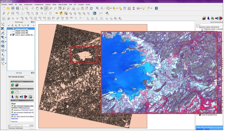
QGIS: Quantum GIS is an open source GIS platform, over the years it has added a great variety of functionalities and complements so that the analyst has the possibility of processing and obtaining different types of products. The interesting thing about this platform is that it can be configured by the user, in addition to the basic GIS interface, there are many plugins that fit the analyst's tasks.
One of the tools that can be used is the Orpheus Toolbox, which contains very useful geoalgorithms when extracting data from a satellite image, be it multispectral or radar. Some of the functions you can find are: Radiometric calibration, support for digital elevation models, band algebra, filtering, radiometric indices, segmentation, classification, change detection.
You can also add the Semiautomatic Classification plugin, where other types of tools dedicated to image pre-processing are provided, such as the change from digital number to reflectance. The data of a large part of the currently active sensors is already loaded. As for the lidar data, in Qgis 3 it is possible to visualize it through the LAStools tool.
ArcGIS: One of the most complete software for managing geospatial data. They have a wide range of functionalities inside and outside the platform to achieve a real data integration. In its latest ArcGIS pro release, even more tools for managing satellite data -imagery- were added. It also has other plugins such as “Drone2map” powered by Pix4D to create 2D, 3D products from drone data and ESRI SiteScan, designed for cloud-based drone mapping, part of the ArcGIS ecosystem, with which images are processed. multispectral, thermal and RGB.
Esri's solutions for processing geospatial information are always very complete and successful, which is why it is considered a leader in the geotechnologies industry.

Sopi: The SoPI (Image Processing Software) is a software developed by CONAE (National Commission for Space Activities of Argentina). With this it is possible to visualize, process and analyze satellite data; it is completely free and its interface is easy to install/manipulate. Its environment is 2D/3D and it is built under the architecture of a Geographic Information System.
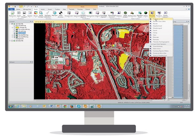
ERDAS: It is a software specialized in geospatial data processing, powered by Hexagon Geospatial. combines GIS tools, photogrammetry, support and analysis of optical images -multispectral and hyperspectral-, radar and LIDAR. With this you have access to 2D, 3D and map views (for simpler cartographic representations). It integrates tools such as: measurement, vector data management, use of Google Earth data, metadata visualization.
Erdas is characterized by being a high-precision platform that allows the analyst to be more productive through their workflows. The handling of this software requires some minimal knowledge in remote sensing, however, it is not difficult to learn. The suite is made up of two types of licensing: Imagine Essentials, at a basic level, and IMAGINE Advantage for specialized users.
I SENT: Envi is another specialized software for remote sensing data processing. It is based on IDL (Interactive Data Language), which offers comprehensive image processing, feature customization and functions for a great user experience.
The suite offers workflows that can be integrated with other platforms such as ESRI's ArcGIS. This software supports all types of images, both from airborne sensors and satellites (multispectral, hyperspectral, LIDAR, thermal, radar and other images). It supports a large deployment of data sets, including 3D data representation, exploration of spectral signatures among others. The ENVI suite includes: ENVI, ENVI for ArcGIS, ENVI EX, and SARScape.
PCI Geomatics: PCI Geomatics, was developed for the visualization, correction, processing of images from optical sensors, aerial photography, radar or drones. Thanks to its GDB (Generic Database) technology, it is compatible with at least 200 types of formats, therefore, it has the capacity to handle large volumes of data stored in databases such as Oracle.
It has specialized modules for the processing of information. For example, with Orthoengine, you can perform automated orthocorrections, mosaics, and digital elevation model generation.
SNAP: The SNAP (Sentinel Application Platform) is an ESA software, intended for the visualization, pre and post processing of Sentinel platform products, although it admits the visualization of images from other satellites.
The system is divided into parts or toolboxes depending on the model of the satellite. Each toolbox is installed separately (Sentinel-1, Sentinel-2, Sentinel-3, SMOS and PROBA-V) and also supports the possibility of configuring the system to work with Python (SNAPISTA). It is very complete, with which you can even add vector data such as shapefiles and information from WMS services. It connects directly to the Copernicus Open Access Hub to access Sentinel products directly.

gvSIG: This is interoperable free software that over the years has improved the interaction between the user and the system. It provides functionalities for band management, definition of ROI's, filters, classification, fusion, mosaics, multispectral transformations, calibration to reflectance values, index generation, decision trees or mosaics through an extension that is installed in the program. In addition, it contains support for lidar data in the format. LAS, with DielmoOpenLidar (a free software with GNU GPL license based on gvSIG), for the creation of profiles, quality control and management of point clouds.
SAGA: System for Automated Geoscientific Analyzes is an open source program, although it is configured as a GIS, it has algorithms for processing satellite images since it comes with the GDAL library. With it, products such as vegetation indices, fusion, visualization of statistics, and evaluation of cloud cover in a scene can be generated.
Google Earth Engine: With Google Earth Engine, the analyst can visualize geospatial data, all in an architecture developed in the cloud. It stores a large number of satellite images and with these they can be displayed in a multi-temporary way in surface change since it includes historical images.
One of the most interesting things is that it allows the analysis of large data sets by integrating its APIs in JavaScript and Python. It integrates a large number of datasets of all kinds, from climatic, geophysical to demographic. It allows adding user data in both raster and vector formats.

Software for LIDAR and Drone data processing
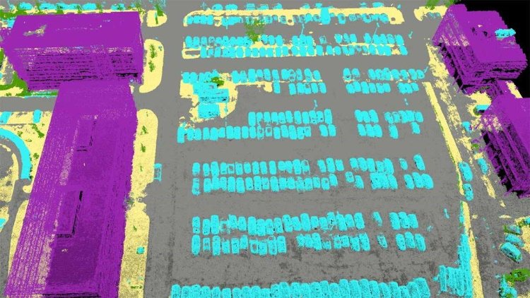
Pix4Dmapper: It is a software focused on the photogrammetric area, aimed at providing solutions for high-precision projects. Through its tools, you can manage point clouds, elevation models, 3D meshes from remote sensing data, and create orthomosaics.
It has very successful functionalities at the time of pre and post data processing. It is widely used in precision agriculture, generating zoning maps to identify productive areas. Accepts the following types of products as long as they are in .JPG or .TIF format: RGB images, drone images, multispectral, thermal, 360º camera images, videos or positioning camera images.
Global Mapper: It is an affordable tool that integrates good tools for handling spatial data, since it supports different types of formats, and provides direct access to different catalogs of high-resolution images such as DigitalGlobe. If you want to process LIDAR-type data, you can add it directly in LAS and LASzip format, in its latest version the rendering speeds were improved to provide a better user experience.
DroneDeploy: Like Propeller, Drone Deploy is a program for the photogrammetry area, it includes everything from the initial phase of the capture process to obtaining the 3D model. With this it is possible: to control the flight of the UAV (specifically DJI drones), it has measurement tools such as area and volume. It can be obtained for free with limitations or a full version that requires a license fee. It is very useful when you want to verify the count of plant species, crop areas in initial or final state, in addition to exploring multispectral and infrared maps within DroneDeploy.
DroneMapper is a software that offers the benefits of a GIS, in a platform to process photogrammetric images. It has two versions according to the needs of the analyst, one free and the other paid for over €160 per year. It is one of the software that is not based on the cloud for data processing, but rather all the procedures are done locally. This means that the computer must meet certain memory characteristics in order to store and run processes properly. Through DroneMapper you can produce Digital Elevation Models and Orthomosaics in Geotiff Format.
Agisoft Metashape: With Agisoft Metashape, formerly known as Agisoft Photoscan, the user has the possibility to process images, point clouds, generate elevation models, or digital terrain models with great precision to be used in GIS applications. Its interface is easy to use and it has a data architecture in the cloud for professional Metashape users. It is a program that requires a license, the standard one is over $170 and the Porofessional is over $3000. It feeds on the Agisoft community to improve the algorithms with which the data is processed.


