
The SINAP National System of Property Administration
 The National Property Administration System (SINAP) is a technological platform that integrates all the information related to the physical and normative resource of the nation, where the different public and private actors and individuals record all transactions associated with property assets. property, necessary for the constitution and dynamization of a stock market.
The image on the right will have seen it somewhere, because it is a scrawl that one day I did in my leisure time on LADM, In one of the exhibitions of Amsterdam, there by 2012.
SINAP was born and implemented in Honduras in a period 2002-2005, within the framework of a Land Administration Program, similar to those that were happening in parallel at that time in several countries under the financial support of the World Bank. It was not born as an extraterrestrial inspiration, its foundation is in the classical theories that support development models, where the guiding elements for the development of markets are, on the one hand, the Decrease in production costs(Raw material, human resources, technology and capital) and on the other hand Decrease in transaction costs. Thus, given the difficulty of reducing production costs in a developing country, SINAP's main scope is to reduce transaction costs and times.
SINAP is not a computer tool, but a set of policies that includes the development of technologies, integration of institutional actors linked to land management and simplification of processes in line with international trends in standards and adoption of information technologies And communications.
 When SINAP is conceptualized, there is sufficient clarity that only implementing a technology, without modifying the regulatory and institutional regulations, is almost like putting tires on a horse, instead of designing a new vehicle. Thus, the strategy is accompanied by a radical change that includes the creation of new laws such as the Property Law and the Land Management Law; Under this legal framework, the Property Institute is created, which brings together the Property Registry (which belonged to the Supreme Court of Justice), the National Cadastre (which was an Executive Directorate dependent on the Presidency) and the National Geographic Institute ( that depended on the Ministry of Public Works and Transportation).
The new institution is constituted with a Directorate of Registries, a Directorate of Cadastre and Geography and a Directorate of Regularization, from an optics focused on outsourcing through Associated Centers that can be constituted by municipalities or entities under a public-private partnership.

SINAP was born under the Core Register Domain Model (CCDM), a document that at that time was an abastracto of Christiaan Lemmen and other geofumadas that sought to materialize the approach of Cadastre 2014.
![]()
The CCDM in 2012 became the LADM (ISO-19152), but by then (2002) it was already a sufficiently mature thought of how things in land administration could be simplified to simple relations of Law, Restriction and Responsibility (RRR ) between the interested parties (Party) and the registration objects (BAUnits), with the cadastre as the spatial referent of objects and cartography as elements of public law that affect private law.
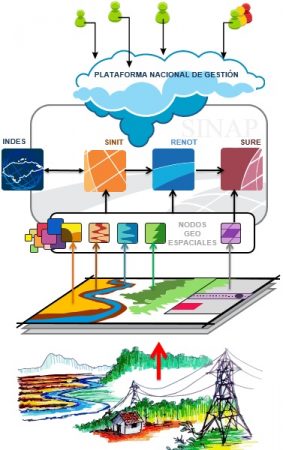
This is the conceptual design of SINAP in the year 2004; with a series of transactional nodes which at that time constituted: SINIMUN for municipalities, INTUR for the tourism sector, SINIA Environment, SNGR for risk management, CIEF for forestry and INFOAGRO for the agricultural sector.

The logo on the right is the one that I had to redesign in 2012, taking care of the identity of the existing one. In a summarized sense, SINAP is a platform that integrates at least four main sub-systems:
The SURE Unified System of Records.
 This system includes, among other records, real property and the cadastral registry as the same reality. It means that the cadastral parcels constitute a complete sweep of the territory, both of private real estate that are linked to the properties registered under the real folio technique, as well as the goods of public use such as streets and rivers linked to the administrative folio. Additionally, the parcels reflect as affectations the intersect suffered by the cartography that is linked to public law, as well as flood zones, protected areas, historic centers, etc.
SURE does not only include real estate; Is an agnostic to gradually integrate the different goods of the nation; Currently includes commercial property, powers, intellectual and vehicular.
The National Territorial Information System (SINIT)
 This system registers and publishes all the cartographic information produced by the different institutions of the country and creates value-added services that it makes available to users under the same projection system. In addition, it advertises spatial information, fulfills the role of an information repository to avoid the loss of information produced by public institutions and also to serve as a publication node for those that do not have the necessary infrastructure to serve the information they have produced.
Registration of Land Use Regulations (RENOT)
 This is a registry that integrates all the regulations that contain attributes of affectation or benefit towards the use, domain or occupation of the plots. The origin of this registry is associated with the Territorial Ordinance Law, seeking that the ordinance plans and public order norms generated by different institutions can be enforceable and reflected as effects on the parcels in the consultation or cadastral certificate, as well as in the management of procedures or certifications in the properties of the Property Registry.
Although the sponsors of RENOT have changed at different times, their concept remains the same as that required for painted maps to be binding: "There must be legal conditions that empower the principles of consent, specialty, publicity and registration, so that the rules of public order are reflected in private property.
The National Spatial Data Infrastructure (INDES)
 Of course, not everything was so easy to implement. In 2002, the subject of Spatial Data Infrastructures was somewhat primitive, at least in these countries where institutional capacities and the academic offerings of universities have little to offer. At that time the fourth system was called Clearinghouse, an eighties term that reminds us of the famous metadata search engines. For the year that I have to reconceptualize it, we call it the National Spatial Data Infrastructure (INDES).
Was SINAP worth the effort?
SINAP has been shown in different international contexts, although in my particular opinion, it lacks writers who wish to tell its benefits from a patriotic approach. For a smoke born from scratch, on a glass table and few cups of coffee, in a country with problems of corruption and political patronage similar to many countries with a Hispanic context, SINAP is an exemplary project in many aspects. Of the four subsystems, SURE was the one that had the best sustainability conditions, since its development was carried out in a time as record as how obsessive its godparents were and because they bet on abusing multiple lobbying fronts for a new legislation and institutional transformation, what is not easy (nor recommended) to carry out in any country; although for this they had to jump obstacles such as not touching the civil code (which one of these days will pass the bill), as well as the limited incidence in the Cadastre-Registry career, although it was included in the certified professionals.
In terms of institutional growth, there are many challenges, as the late process of institutionalization of the Project, the lack of a civil career and an unpredictable union of employees has almost brought to collapse the most glorious moments of the Institute of Property; However, SURE as a technological platform deserves the respect that has allowed it to continue operating as an official platform.
The free software for that time was not seen with maturity optics, so it was necessary to use a lot of proprietary technology, to give an example:
- The digital mapping was mechanized developing over VBA, from the massive plots registration, to the historical version of the DGN V8, with control of checkin-checkout using ProjectWise,
- Using an ActiveX web viewer, users in the municipalities requested maintenance transactions using DGN redline, GeoWeb Publisher, and Web explorer lite.
- The generation of cadastral certificate could be done from the client of Microstation Geographics, generating the map, cadastral data and course chart just by choosing the cadastral key; while online it could be generated using GeoWeb Publisher, individually or massively, generating PDF files containing alphanumeric and graphic data.
- The scanning and extraction of the Registry books were done with automated applications that returned this arduous task in a maquila process, that later even was outsourced to private companies.
- The transactional platform of cadastral and real folio was developed totally web.
Perhaps the use of all those technologies, all those users and that level of automation earned it the BeAwards award in 2004 (today BeInspired), in the environment management category and in 2005 in the Government category. But the acid test was when in 2006 he had to face a political change with a different party and all those traditional tactics of political patronage and the desire to erase everything and start from scratch.
One morning they came with an external disk (which was new at the time), to say that the Unified System of Records were kept on that disk ... they stopped asking when they realized that they would need many external disks.
Another morning, someone requested the management of the database administrator user. After two days he had forgotten the password, and it was necessary every three days to start the database after the automated backups at midnight, since at that time there was no server virtualization and a replica remained active while the backup between 12 at night and 6 in the morning.
Registers already using the system began to complain, and then the boy realized that the System was more than just nice graphics to impress in PowerPoint Presentations.

Certainly from the mistakes made there are more useful lessons that the different users who participated in the conceptualization, design, development, documentation, implementation and institutionalization level will be able to tell. When a system is innovative, and people are participants, the opportunities behind this experience change their lives, beyond the knowledge acquired.

What cannot be denied about the commitment of Honduras, with SINAP, is that with the passage of time, the initial vision has not changed. The system managed to survive three periods of government, including a coup (2009); in this period there was every possibility of failure, but the application of the principle of common sense was important "If you're going to make a great system, make it work fast“; when they wanted to go back to using books, the same users defended it. Currently, 16 of the 24 registration districts, which already operate on the system, have been modernized. In 2013, an evolution plan was made to migrate to a new platform all those functionalities that were deprecated, incorporate open source software to improve sustainability, and adjust the business model to prepare it for the integration of a private operator, with the adoption of the LADM standard and BlockChain technology for data securitization. One of the main additions was packages in the Spatial database, which are executed from triggers, so that if a new geometry is registered with normative linkage (such as a new protected area), all the cadastre Parcels are automatically affected and appear as a preventive alert in the Registry farms; Open source technologies such as OpenLayers, GeoServer and GeoNetwork were also incorporated to replace GeoWeb Publisher and BentleyMap to replace Microstation Geographics; for the municipalities, web services were developed to interoperate via WFS over a QGIS plugin.
 In the following graph I have captured SINAP's time path, which seeks to overcome the two Catastro declarations 2014 that have not yet been overcome: that the private and public sectors work together, which is leading to a reckless proposal for a public-private alliance and a greater exploitation of business intelligence that allows costs to be fully recoverable.

Under the new vision, the SINIT and RENOT systems are no longer necessary as additional systems, as suggested by the technological limitations and power lawsuits of 2004. SINIT is just one more registry of SURE (The Cartographic Registry) and RENOT the Normative Registry; the new system is still under development; The graphic below reflects some of your technology infrastructure.
If things continue at the current pace, SINAP will be able to fulfill its premise that was from the beginning under the concept of Associated Centers; being the Registry and Cadastre only regulatory entities within a Centralized system operated under a Front-back office scheme.
Thus, the municipalities are responsible for the cadastral update and provision of services associated with the transactions; Currently, several municipalities are doing it under a delegation scheme, mortgage transactions are already operated directly by some banks, such as peripheral offices, like the Mercantile Registry that is operated by the Chamber of Commerce and a candidate to do much more than that ...
Certainly a great weakness of SINAP will be for a long time, the lack of poets who speak of its potential from conceptual, technical and technological levels. A pity, considering that it is perhaps the first materialized flag of LADM, before it was a standard (CCDM); merit that other countries such as Colombia will take, where this type of glories are not stopped taking advantage of and are inserted in public policy, as reflected in the CONPES 3859.
The lessons learned from SINAP are at least 8, and very valuable… having been part of that smoke is invaluable. There will be time to talk about it, happy end of the year 2016.


That's right, the new version, which is still under development, includes services so that users who consume, update and publicize information on territorial management can be integrated. One of these examples is the Municipal SIT, from which municipalities can perform cadastral maintenance in the Cadastral module, but which also includes a territorial ordering module from which they can integrate their land use plans.
Awesome. I can not even imagine the difficulties of carrying out a similar project. Have you considered the possibility of consulting the information through APIs? This would make it possible for other agents, such as NGOs working on territorial planning in the country, to integrate their workflows in a simple manner with the national cadastre.