
Downloads
Download of applications promoted by Geofumadas or products of general interest
-

6 geo-engineering publications for free download
Today we will present you ebooks and publications to understand the technological advance in the field of geo-engineering and its impact on everyday life. All options completely free and easy to obtain. Faced with the dizzying growth of technology...
Read More » -

View Google Earth coordinates in Excel - and convert them to UTM
I have data in Google Earth, and I want to display the coordinates in Excel. As you can see, it is a field with 7 vertices and a house with four vertices. Save Google Earth data. To download this data, do…
Read More » -

How to download AutoCAD 2018 - educational version
The educational versions of AutoCAD are fully functional, both for students and teachers. To download AutoCAD student version, follow these steps: 1. Access the AutoDesk page. Login to your account or create a new one.…
Read More » -

Break the password of a VBA macro from Microstation
Visual Basic for Applications is a series of libraries that Microsoft made available, somewhat old-fashioned but very powerful, especially in versions of Office before 2010. Although it continues to exist, many developments are now being made…
Read More » -

Draw a polygon in Microstation from Excel
Using this template, a traverse can be drawn in Microstation, from a list of bearings and distances in Excel, or a list of coordinates x, y, z. Case 1: List of Bearings and Distances Suppose we have…
Read More » -
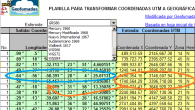
Earn the UTM template to Geographic by promoting Geofumadas
For a limited time we will be giving away the "Conversion from UTM to Geographic coordinates" template, promoting Geofumadas. With this template you can enter a UTM coordinate, as an example: X=1,740,564.29 Y=3,396,718.08, indicating zone 19 to the north. and Spheroid GRS80, and as a result…
Read More » -

Template to create dxf file from list of points in Excel
Juan Manuel Anguita has recently passed me the new version of this application that we had previously promoted, but that time had left with some problems with the new version of Excel. Its use is very simple, but extremely…
Read More » -

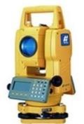
Sokkia Series 50 Total Station Manual
Some time ago a reader was looking for this manual, months later he found it and sent it to me. Returning the favor, I'm posting it here so you can download it. This is the operator's manual, official from Sokkia,…
Read More » -
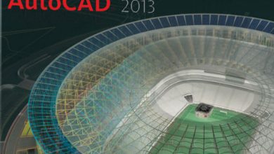
Free AutoCAD Course, Available for Download
Some time ago we published the version of this Free AutoCAD Course, now the version for AutoCAD 2013 has been released, in which you can download the first section for free and additionally: Now you can buy it for…
Read More » -

The cadastre, explained in popular version
This is one of the last publications in which I have had to work. It is an explanatory document that although it was made for one context, it could surely be useful for other countries in this complicated task...
Read More » -

Convert decimal geographic coordinates to degrees, to UTM and draw in AutoCAD
This Excel template is initially made to Convert geographic coordinates in UTM, from decimal format to degrees, minutes and seconds. Just the opposite of the template that we had made before, as seen in the example: Additionally:…
Read More » -

Export list of geographic coordinates to Google Earth, from Excel, with image and rich text
This is an example of how Excel can send content to Google Earth. The case is this: We have a list of coordinates in decimal geographic format (lat/lon). We want to send to Google Earth, and we want the…
Read More » -

Excel to Google Earth, from UTM coordinates
Let's see the case: I have gone to the field to build a property, as shown in the following table and I want to visualize it in Google Earth, including a couple of photos that I have taken The genius of the template is that…
Read More » -

Draw a polygon with bearings and distances from Excel to Microstation
A few years ago I published an article in which I showed how to concatenate data in Excel to build a traverse with AutoCAD, without having to do the whole protocol: @distancia
Read More » -

MobileMapper and Promark in Spanish
A few days ago a reader asked me about the MobileMapper 100 Basic User Guide. These manuals usually come on the disk that accompanies the equipment purchased from Ashtech, also in German, French and English with the names: xM100&200Platform_GSG_B_es.pdf…
Read More » -
BiblioCAD, download AutoCAD blocks and plans
BiblioCAD is a site that contains an invaluable amount of files ready for download. You can easily solve it when you are doing a project or give us new ideas on how to develop it. Let's see some cases: We occupy a detail of a…
Read More » -
Manuals for use of GPS and total station Leica
Following a link from the gvSIG distribution lists, which today has made the final version 1.10 official, I have found an interesting site. This is Openarcheology.net, which, promoted by Oxford Archeology, seeks to promote the use of tools and…
Read More » -

Convert degrees/minutes/seconds to decimal degrees
This is a very common task in the GIS/CAD field; a tool that allows you to convert geographical coordinates from heading format (degree, minute, second) to decimals (latitude, longitude). Example: 8° 58′ 15.6” W that requires conversion to decimal format:…
Read More »