The TwinGEO Integrated Territorial Framework
TwinGEO is an integrated territorial Digital Twin framework designed to align territorial systems, data integration, digital assets, sensing, and decision support into a coherent architecture.
It is grounded on a simple observation:
Most digital initiatives fail not due to lack of technology, but because they do not reflect how territory actually operates — as an interconnected system across natural, built, social, and economic environments.
TwinGEO provides a structured model to organize this complexity before tools, platforms, or implementations are considered.

The Problem of Fragmentation
Most digital initiatives evolve in silos:
- GIS models disconnected from engineering design
- BIM models isolated from territorial context
- Infrastructure data detached from lifecycle processes
- Analytical tools disconnected from decision-making
Each discipline optimizes its own models, but the territorial system remains fragmented.
The result is consistent:
- duplicated data
- inconsistent representations
- digital outputs that do not influence decisions
TwinGEO addresses this by establishing a common architectural structure aligned with the territorial system itself.
A Layered Architecture of Territory
Territory is not a collection of datasets.
It is a system where environments, assets, and processes interact over time.
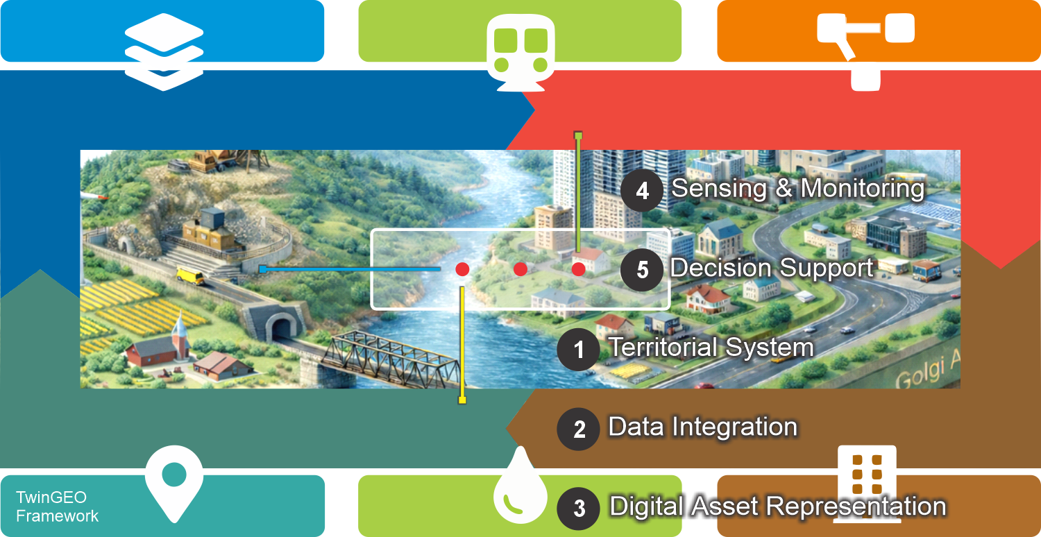
TwinGEO structures this reality through five integrated layers:
- Territorial System
Defines the real-world system across natural, built, social, and economic environments. - Data Integration
Connects information flows across processes such as construction delivery, territorial development, utilities delivery, and land administration. - Digital Asset Representation
Structures persistent assets as domain-enabled entities, allowing them to be interpreted through different functional logics. - Sensing & Monitoring
Validates the system through real-world data, enabling feedback between operations and representation. - Decision Support
Enables aligned, traceable, and evidence-based decisions across the territorial system.
This layered architecture allows complexity to be addressed without fragmentation, preserving both structure and evolution.
From Territorial System to Decision Support
TwinGEO does not start from technology.
It starts from territorial logic.
Decision-ready systems emerge when alignment is achieved between:
- the territorial system and its environments
- integrated data across processes
- persistent digital assets structured by domains
- continuous validation through sensing and monitoring
When these layers operate in synchrony, decision support becomes operational rather than aspirational.
Why a Framework Matters
Without a structured framework:
- models evolve in isolation
- data becomes fragmented
- digital systems fail to support decisions
TwinGEO acts as a structural backbone that ensures coherence across disciplines, processes, and technologies.
It enables professionals to:
- think in systems, not tools
- design digital twins incrementally
- maintain alignment between territory, governance, and digital representation
Explore the TwinGEO Framework
The framework can be explored through its five integrated layers:
Territorial System
The real-world system across natural, built, social, and economic environments
→ Explore Territorial System
Data Integration
How information connects across processes such as construction, utilities, land administration, and territorial development
→ Explore Data Integration
Digital Asset Representation
How persistent assets are structured and interpreted through domains
→ Explore Digital Asset Representation
Sensing & Monitoring
How real-world data validates and updates the system continuously
→ Explore Sensing & Monitoring
Decision Support
How integrated information enables aligned and evidence-based decisions
→ Explore Decision Support
Each layer represents a complementary dimension of the same integrated territorial system.
A Framework Designed to Evolve
TwinGEO is intentionally tool-agnostic and technology-independent.
This allows the framework to:
- adapt to different institutional contexts
- scale from local implementations to national systems
- remain valid as technologies evolve
The value of TwinGEO lies not in prescribing solutions, but in providing structural clarity.