Timeviews - Plugin to access historical satellite images with AutoCAD
Timeviews is an extremely interesting plugin that allows access to historical satellite images from AutoCAD, in different dates and resolutions.
Taking the digital model of contours that I have downloaded from Google Earth, now I want to see historical images of this area.
1. Select the area of interest.
The process is simple. The Timeviews tab is selected, then the “View Imagery” icon, clicking on a point in the center of the area that interests us and that raises a panel that says that around that coordinate there are images available with different capture dates :
- 1 zoom image 19, with pixel of 30 centimeters,
- 1 zoom image 18, with pixel of 60 centimeters,
- 7 17 zoom images, with pixel of 1.20 meters,
- 7 16 zoom images, with pixel of 2.30 meters,
- 7 15 zoom images, with pixel of 4.60 meters,
- and 7 zoom images 14, with pixel of 9.3a meters,
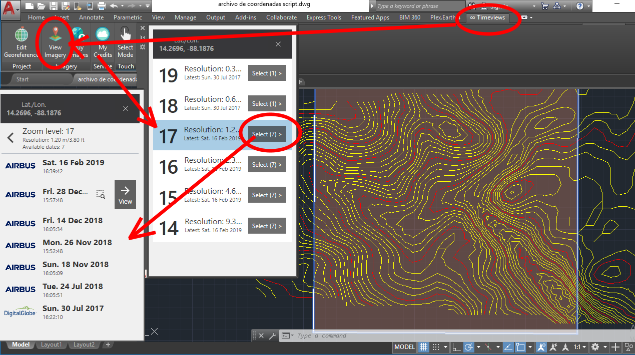
When I select the 17 resolution, then it shows me the dates of those images:
- 6 of them are from Airbus with dates July, November and December of 2018, and that the most recent is just two months ago (16 of February 2019).
- It also shows me that there is a DigitalGlobe of July from 2017.
2. Unfold the selected image.
Once the image is selected in the View option, we can see the image in the resolution provided and in the AutoCAD layer that we have in use.

3. Add a historical sequence.
By clicking on the “add time views” button we can choose a sequence of images of the same area to make comparisons.

3. Acquire the images.
The application is definitely very interesting, as it allows you to view available images of an area and even the possibility of purchasing them from the provider. It must be taken into account that the available images are not a mosaic, but sequences of satellite images with some overlap. The following image shows the overlap between two Zoom 19 images and one Zoom 14 image that is in the background.

The service is not yet available, but it will be a premium functionality of the Plex.Earth Plugin for AutoCAD.
In general, I find it quite interesting, with many potentialities; On the one hand, to find out information available for a specific area, to make comparisons of historical changes. The best, that works on AutoCAD, even on recent versions; With a vision of "software as service" because without the need to buy the image, satellite images can be used by having a subscription to the Plex.Earth service.
In terms of improvements that could benefit the user is to show a grid of boxes of the available coverages in a deployed area, instead of going point-to-point; as you can see some coverages in Google Earth.