
The World Geospatial Forum (GWF): A necessary appointment for professionals in the geospatial sector and related
If you are a professional in the geospatial sector and you like new technologies, then the Geospatial World Forum (GWF)) is an unmissable appointment. This is undoubtedly one of the most important events in the area of geotechnologies, which together with other events of this level give sustainability to the industry.
What is the World Geospatial Forum – GWF?
It is an event organized by Geospatial Media and Communications, which brings together an impressive number of leading geospatial industry experts. Its influence impacts the trend, both in good practices and the definition of guidelines for the Government, Academia and industry sectors, since it is the leaders of these environments who attend, show and promote the use of the latest trends at the event. and adoptions in this field.
The GWF is held annually in different parts of the world, since 2011. This year it will be held in Rotterdam – The Netherlands, and the main theme is: Geospatial Caravan or “Geospatial Caravan: embracing one and all”. With this theme they seek to show how geotechnologies are now part of people's daily lives, and what is being done to facilitate/regulate access to them. Together - the citizen, government, companies and space technologies -, can create or devise a better world with greater opportunities.
With the theme “Geospatial Caravan: Embracing One and All”, GWF 2023 It will bring together the global geospatial community spanning governments and public sector bodies, industry, academia and civil society. The goal is to know how we can simplify the technological, institutional and workflow complexity and increase the impact for the good of society.” GWF 2023
Partners and Sponsors
Sponsors have always been key in any event or conference, they attract professionals, investors and promoters of new solutions. In turn, they promote continuity, and in this case, GWF has been providing a space where the latest innovations or advances are discussed for more than 10 years. Companies like ESRI, Trimble, Merkator, RIEGL, the European Association of Remote Sensing Companies, Commercial UAV News, GeoAwsome, ISPRS, and of course, we cannot ignore the participation of Geofumadas, which since 2007 has been dedicated to sharing, generating and promote the use of CAD – BIM – GIS information technologies.
The GWF has featured speakers from various sectors, such as administration, industry, academia, even non-profit organizations. The participation of world leaders who offer a vision of the geospatial future and its possible applications always stands out. You can click on this link to see the speakers of this 2023.
Events and activities
 The GWF has become a fundamental part of learning, exchanging ideas and new collaborations on a wide range of topics, such as remote sensing, GIS, mapping, surveying, geotechnologies, GNSS / GPS, UAV / drones, mapping systems. mobile and much more. Therefore, it is not just an event to see and listen to, it is a place where they can be trained through training programs, meetings behind closed doors and round tables for discussion, on other occasions activities such as hackathons are also carried out.
The forum includes two large events that converge in parallel, the GeoBIM and the GeoBUIZ Europe Summit.
The GeoBIM, brings together experts who have worked on technologies for the built environment, the use of the Internet of Things or IoT, 3D printing, Artificial Intelligence, and 5G. The theme for this year's GeoBIM is “The digital transformation of cities and the built environment“, with the following categories:
- Buildings
- transport infrastructure
- Urbanism
- Mobility
- city services
- green building
- Profit Share
- underground infrastructure
- digital twins
- Digital Infrastructure
- Metaverse
- Asset Management
The GeoBUIZ includes more than 50 speakers on irreversible industry trends, in at least:
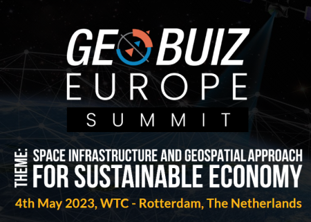 Glean Europe's approach to driving geospatial innovation and entrepreneurship,
- Space infrastructure trend and geospatial approach by industry,
- Collaboration and partnerships powering the technology ecosystem for agile delivery of workflows,
- Interaction with leaders of the space, geospatial and technological allied ecosystem.
In this way, through the two events a complete theme is reached that can be summarized as follows:
- Data and economics.
- land and property,
- Space,
- Geospatial Knowledge Infrastructure Summit,
- geology and mining,
- hydrography and maritime
- Focus on the user.
- GEO4SDGs – relevance to the digital age and its impact on development goals,
- BFSI – location intelligence + fintech and the reshaping of financial schemes,
- Retail and Commerce – driving innovation with location intelligence,
- Geo4Telcos – 5g geo-enabling operators.
- Technological focus.
- LIDAR – Technology based on light detection and ranging,
- AI/ML – Artificial Intelligence/Machine Learning,
- HD Mapping – High definition mapping,
- SAR – Synthetic Aperture Radar,
- PNT – Positioning, navigation and timing.
- Special sessions.
- Diversity, equity and inclusion,
- Geospatial Women's Networking Event,
- Startup Mentor Panel,
- Geospatial rising stars.
- Parallel programs.
- Regional Forums,
- Training programs,
- Partner Programs,
- Meetings behind closed doors
- Round Tables.
The GWF Agenda
For now we will show you how it is distributed on the first day, for the second day you can check it in the following link.
- In the plenary session of the first day, the following will be discussed: Geospatial Convergence and BIM for the Digital Built Environment, Digital Twins, and the Metaverse: Bridging the Physical and Digital Divide in Infrastructure Workflow, Build, Harden, Secure: Digital Infrastructure for Smart Cities
- In room A, “Digital transformation of the built environment”, the main themes are: Bringing Sustainability to the Design, Construction and Operation of Buildings and Infrastructure and From 3D to Digital Twin to Metaverse: Transforming the Construction Life Cycle Approach
- In room B “Digital cities: a holistic approach for the urban transformation that we will have”: Digital twin for planning digital cities: best practices, strategies and case studies, improving mobility, access and security with geotechnologies and GEOBIM award presentations and reception of networks.
“The digitization of the built environment, i.e. the integration of physical assets and advanced 4IR digital technologies, ensures that infrastructure projects can no longer be planned, designed and built in isolation. As information-based modelling, new materials design, spatial planning, and integrated design solutions are expected to unfold at multiple levels of the built environment, the integration of geospatial technologies with BIM will become increasingly common.” GEOBIM 2023
The GWF Awards
Finally, a very special and long-awaited activity is the GEOBIM 2023 Awards. Prizes awarded to all those who have proven to be an example of technological excellence in architecture, engineering and construction. The award ceremony will take place during the GEOBIM conference on May 4, 2023, and eligibility depends on the implementation of innovation projects or policy formulation that promote the use of geotechnologies.
Three categories are the main ones: Excellence in surface transport systems, Excellence in Digital Innovation and Excellence in asset management. Each of them is divided into other subcategories. We look forward to seeing this year's nominees and winners.

Last year's winners for excellence in their categories were:
- Excellence in Public Health: Johns Hopkins Coronavirus Resource Center (CRC),
- Excellence in Public Safety: Penang Women's Development Corporation, Malaysia,
- Excellence in Urban Planning: Ministry of Land and Natural Resources and Ministry of Local Government, Zambia,
- Excellence in Land Administration: Department of Land Resources, Ministry of Rural Development, Government of India,
- Excellence in Agriculture and Food Security: Food and Agriculture Organization (FAO),
- Excellence in Water Security: UN Assistance Mission for Iraq and UN Department of Political and Peacebuilding Affairs,
- Retail Excellence: Procter & Gamble,
- Excellence in Utilities: Grand Bahama Utility Company (GBCU) and ASTERRA,
- Excellence in construction and engineering: Skanska Spain,
- Platform of excellence in content: Federal Office of Surveying swisstopo – Swiss Geological Survey.
While the innovation winners were:
- Innovation in Location Intelligence: NextNav,
- Innovation in Aerial Mapping: Vexcel Imaging,
- Innovation in mapping the seabed: Planblue,
- Innovation in SAR-Optical Data Fusion: Thetaspace,
- AI Innovation for HD Vector Maps: Ecopia AI
Tips for attending the GWF
As in any event, everything there is to see and enjoy is usually overwhelming, therefore, it is convenient to have a planned visit. Some of the advice that we can offer you before attending is the following: Consult the programs and identify the sessions and activities that you wish to attend, bring your business cards – there are opportunities to connect with different companies and important personalities-, take note of your doubts to be able to consult them, do networking – it is the only way to have new partners, clients or mentors-, do not let this great opportunity pass you by. Take advantage of your time.
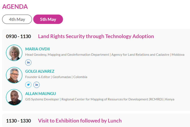
In particular, we have the great satisfaction of participating with other world leaders in the GWF2023 as speakers in the Land and Property category, where we provide good practices from the projects in which we participate and share about the trend of adoption of technologies for land property rights.
To register, you can enter the main web where the conditions for access are shown.


