
The employability oriented to the GIS. Fiction versus reality
After reading an article that begins by asking what the GIS employers are really looking for, I wondered how far these conclusions can extrapolarse to our countries of origin whose realities may be similar or different (perhaps very different) from yours.
The 'raw material' used for the study were all job offers in GIS published in various means of public access. Those offers handled by the 'head hunters' were not included due to the private scope of their diffusion.
Keywords were used to record job searches on three of the most popular websites in New Zealand. "GIS, Geography, Location, Space, Geography" were the words used for this purpose.
Once the notices were registered, the collected data was filtered, eliminating duplicates and 'false positives'. Subsequently, from each notice the characteristics requested for the required position were extracted. The attributes extracted and then stored were:
- Title of the job offer
- Advertising made by the applicant company
- Main sector of work of the applicant industry
- GIS as the main or secondary requirement for the requested work
- Technical skills required at software level
- Location of the position and,
- Salary
We find it extremely important to stop here and highlight some themes before to present the findings of the study. Let's see:
-
The 'GIS industry' with naming and confusing concept
"One of the reasons I did this study is because I wanted to have an empirical method for determine the structure of the GIS industry in New Zealand. "writes Nathan Heazlewood, the author of publication which we discussed. And while in our article "The many possibilities"We tried to clarify the concept, it seems that the term currently still produces many doubts.
Note that the two articles that I will take as reference are the same author and this year, the 2017. I will then pose, with your permission, a kind of allusion to the analysis because, as you will deduce from reading, All is interrelated.
"The GIS industry can be confusing. It is complex "are the phrases with which Heazlewood starts his post"The great tribes of the GIS industry”. And he continues, "Confusion is never good." First point. Do we have a clear concept? And if not, which is very probable, how to find the term with which we will denominate this area of work and that really allow us to all understand that we mean it?
Good Nathan transcribes the terms we usually use: 'GIS Industry', 'Space', 'Geomatics', 'Geospatial', 'Location Science', 'Particular Branch of Geography' and finally 'some other term' ( the apocalypse!). Which one of them fits best?
This is not a minor argument as one might think. Because of this first 'confusion' will arise the great doubts that will directly affect three labor variables used: the title of the work required, the extent to which GIS is a main or secondary requirement at work and what is the primary sector of the company applicant. Let us continue.
-
The sweet charm of the titles
 It is enough to capture a small part of the different titles used to designate "professionals of the area" in the Heazlewood study to realize how tangled this sort of 'jungle of titles and denominations' is:
Being a step away from drowning, fortunately, we remember the article "The great tribes ...". In this, Heazlewood tries a thesis of work that is very useful and that, in our opinion, helps positively to clarify this nebulous panorama.Second point. Sure, with business cards that deben reflect a good personal marketing and, in this eagerness to introduce ourselves to the world in the best way, they start to generate the most outstanding differences: the 'graduate', the 'junior' and of course the 'senior'. Could someone explain clearly the scope and limits of everyone of the titles shown? HE 'overlap'functions among some of them? Good question! I suggest revise the complete table published by the author as well as the consolidated table created by him based not only on the research done but also, above all, on his extensive expertise in the area.
"What I can conclude is that there are four large 'tribes' in the GIS industry:
(1) The '... Gists'
(2) The '... Graphers'
(3) The 'Measurers'
(4) The 'Techies'
Using a chart, try to help us understand your idea:

Attentive now with its 'conceptual description':
"(1) 'Gists' are basically some of the leading analysts and users of GIS data that focus on scientific analysis (hence many of their job titles end in '... GIST'). It also includes (or may include) other types of analysts.
(2) 'Graphers' are people who focus on the display or representation of geographic data, such as cartographers and their 'relatives'.
(3) Measurers are those who collect geographic data using both measurement and image tools.
(4) The 'Techies' that act as a sort of interface between the GIS industry and technology. Referring here to GIS developers and their related colleagues. "
After this excellent (to our understanding) explanation, our overview is clarified, is not it? Let us return to our analysis.
-
Third point. The factors that are also of interest to the analysis
En First, How, through a simple announcement, it is possible to determine if GIS is or is not the primary occupation sector of the applicant company?
This does not seem to be very simple to determine beforehand, Heazlewood explains, and then details:
- There are organizations that although they are publicly presented through a commercial image focused on a specific area, they actually provide services to more than one industry. Such is the case of civil engineering companies that can provide services to industries belonging to the fields of communication, services and construction.
- There are organizations that can fit into different categories, such as the Ministry of Transport, which can be categorized under the Central Government heading, but which could also be very well classified within the transport industry.
In both cases it is the analyst's criterion, based on your experience, who will make the decisions that he deems appropriate.
En second place and attentive to all, what or what are the technical skills required at the software level mentioned in the GIS employment notices? Here, the author expands a little:
- It was avoided to consider 'families of products' and it was privileged those software products of the family that were required, for example AutoCAD instead of simply CAD.
- On the other hand, 'related tools' were added to the analysis such as SQL or HTML. This has a lot of logic. And it helps us to have a better approximation of what the market demands.
- It is understood that some notices specified more than one type of software. Perhaps with the desire to filter and segment the interested public. Here we take the example transcribed by the author, but surely must be familiar within their contexts. A sort of examination of knowledge, here we go:
"We are a company that works with ... (verbal, verbal, now comes the interesting) a) We expect an essential understanding of html5, css3 and experience in server-side language, b) An understanding of the following concepts is necessary: cors, cdn, xss, accept headers, ddd, cqrs, tdd, REST, event sourcing, pub sub, microservices, soa, mvc, mvvm, IoC, SOLID, DRY y YAGNI"Standing, standing, we continue:" We are using coffeescript, svg, d3, crossfilter, velocityjs, leaflet, momentjs, bootstrap, less, nodejs, gulp, redis, rabbitmq, expressjs, handlebars, oauth2, passportjs, and docker... ". Now the end point (better have started here) "c) Some knowledge of web mapping frameworks y GIS technologies".
Note that it says "some knowledge in GIS", Did not they want experts? It seems that the 'expertise'does not involve the GIS much ... Better we leave it there and continue.
- 31% of the ads did not specify any specific software (they only said things like “must be competent in GIS”). This seems to be the other side of the balance. And the author reflects: "It can not be known with certainty whether these warnings are due to employers assuming that if you know a GIS, you know everyone, or if employers do not know what skills they specifically want." A very interesting question, right? How to know?
A chart showing the software technologies organized according to the most number of times named in each of the 140 sample notices accompanies this analysis:

And because of its importance, we allowed to show in a table, the ten (10) top tools named:
| Tools | Number of mentions |
| Esri | 49 |
| SQL | 25 |
| Python | 19 |
| SAP | 16 |
| . NET | 12 |
| HTML | 12 |
| JavaScript | 12 |
| FME | 10 |
| Visual Basic | 8 |
| AutoCAD | 7 |
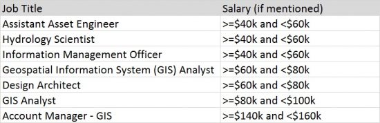
En third place, salary. Recall that the study is done for New Zealand. Its currency, the New Zealand dollar (NZD), has an equivalence of 1 NZD = 0.72 USD (American dollar). It should be added that, since they are different realities in each country, we can only take it as a referential data. In the box shown, 'k' surely expresses 'thousands':
-
Four point. Reality vs. Fiction. Warnings to keep in mind
It seems obvious that any investigation presented in public as well as (and perhaps with priority) the conclusions that can be drawn from that must have a proven scientific rigor and be proven truthful. Heazlewood expresses his fears about it and warns:
- Be alert when you perceive 'opinions' and 'different facts'. We must be able to recognize those 'experts' whose predictions are not based on evidence serious but rather are aimed at subliminal advertising to the companies they represent.
- Stay alert to 'opinion polls'. Those surveys carried out on a voluntary basis often fail to conform to true representative samples of the industry, and the results can lead to erroneous conclusions.
End this reflection by suggesting that all studies of this type should leave their 'source data' free (as they do) because others could perform the same analyzes and verify that it is possible to reach the same conclusions.
-
The target audience of the study and the inherent recommendations
The author claims to be a mentor and / or mentor to GIS graduates and students. They commented that "they often have very little knowledge of the industry to which they are about to enter, also ignoring the existing job opportunities as well as the courses / studies they should follow to improve their chances of getting jobs." All this was an additional reason to carry out the research we are talking about.
This ignorance mentioned by young people is a reality present in any context. Therefore, we emphasize and agree with the author on the importance of working with reliable data that allow us to arrive at objective and truthful conclusions.
And as any committed mentor is concerned with establishing any alumni and student reading their work you should not worry too much about knowing and applying todas the tools named in the job notice copied and listed above, which surely produced more than one cramp in many. Then add this that we do not hesitate to share and transcribe verbatim: "IF YOU DO NOT HAVE ALL THE SKILLS NAMED, DO NOT WORRY." To add sarcastically: "I've only heard some of those terms in my workplace." Fifthly to be taken very into account.
The findings of the study
And we arrived! We highlight here only those that allow us later general comments:
- Un 53% of the published notices take GIS as a complement to the requirements requested for the post, while a 47% focuses on GIS as a core component of your application.
- Local government agencies offer three times more posts than central government agencies.
- The 15% of jobs in GIS are related to transportation, logistics or deliveries.
- Daily notices of work published in GIS in New Zealand.
Final comments
We are clear that the reality of each country is different. However, we can not stop asking ourselves, regarding our environment:
- How much GIS is required as a basic component in job proposals?
- Depending on the political-geographical division of your environment, in which areas of the public-governmental sector or the private sector are the largest labor proposals in GIS generated?
- What are the areas of industry that most demand professionals in GIS?
- How often do GIS job offers appear in the various media?
Questions whose answers we should strive to obtain. Then we end this topic with a question that we hope should become one of the points of personal reflection:
Are you aware of the reality of the GIS industry and its possibilities on the continent or subcontinent to which you belong?


Excellent article. Very good research and analysis of results and I totally agree with what is stated here. I have been criticizing the names of the positions requested on the Internet for a long time since they bring more confusion than clarification. The concept of Spatial Analysis has been lost and has been replaced by “Developer” or “Programmer”. It is intended to pay to know GIS but it is intended that we be experts in programming and network management. I think it is time for GIS to be licensed and regulated under Geography departments internationally.