Technological news in Geo-engineering - June 2019
Kadaster and KU Leuven will collaborate in the development of the NSDI in Saint Lucia![]()
Even after many efforts, within the public sector, the broader / wise use of geospatial information in daily governance, public policies and decision-making processes has remained limited. In an effort to help the development of the National Spatial Data Infrastructure (INDE) in Saint Lucia, the Department of Physical Planning (DPP) of the Government of Saint Lucia has formulated a project.
As part of this project, Kadaster and KU Leuven (University of Belgium) will help develop a sustainable NSDI in Saint Lucia. The project is receiving funds from the International Development Association and the Strategic Climate Fund. It is part of the government's Disaster Vulnerability Reduction program. As a step towards strengthening the NSDI in St. Lucia, Kadaster and KU Leuven conducted a preparation assessment of the NSDI in January.
As part of the evaluation, key members of the DPP staff and other stakeholders in St. Lucia were asked to rate different aspects of the NSDI on open data, standardization, metadata, geoportal, legislation, leadership, human resources, accessibility, finance , among others. The evaluation provided good information on how ready the interested parties are to use the NSDI in their daily work processes.
The objective of the project is to analyze the underlying reasons for the use and acceptance of existing geospatial facilities and data. By investigating the legal, financial, institutional and technical conditions of the INDE of Saint Lucia, the team will give recommendations for improvement. In the coming months, the project team will review the current situation, provide recommendations and develop a strategy for change.
A new Hexagon direct scan laser scanner that makes 3D scanning possible without aim![]()
The Leica Absolute Tracker ATS600, from the manufacturing intelligence division of Hexagon, is a new product that can accurately locate a point in the 3D space with a precision methodology that does not require a reflector at the measurement point. Based on the Wave-Form Digitizer technology that is behind some high-end surveying tools, the ATS600 works with the first Absolute Scanning Distance Meter, an iteration of this technical principle that can locate a point within 300 microns from 60 meters away By measuring a series of points within a user-defined area, the ATS600 can quickly produce a grid that defines the target measurement surface. The density of the grid of points is also customizable by the user, which gives the operator complete control of the balance between the speed of the process and the level of detail that will feed the metrology software.
With Leica's ATS600 Absolute Tracker, objects that previously required a large investment of time to be digitized, or were far from the possibility of having an efficient measurement, can be brought to the world of 3D analysis by a single operator. With the world's first "direct scan laser" tracker, quality control can be expanded to other completely new production areas, driven by a fundamental change in the way 3D measurements are made.
The ATS600, also offers features of the already known Absolute Tracker products, including the measurement of the reflector at a distance of up to 80 meters, with full PowerLock capacity. The combination of reflector measurement and direct scanning capabilities offers impressive performance for large-scale measurement tasks, with the scanning the surfaces are quickly described, and with the individual reflector readings alignments and feature definition are performed.
MICROSOFT HOLOLENS 2: A NEW VISION FOR COMPUTING

The mixed reality in HoloLens 2 combines a device with applications and solutions that help people learn, communicate and collaborate effectively. It is the culmination of Microsoft's advances in hardware design, artificial intelligence (AI) and development. Until now, HoloLens 2 offers the most comfortable and immersive mixed reality experience possible and available, with solutions that the leading companies in the industry are taking advantage of immediately.
ENVYTABLE FEATURES
Immersive: With HoloLens 2 you can see several holograms at once, through the incredible increase in the field of vision. The text and the details that are often confused in 3D images, can be read more easily and comfortably with a resolution that is currently leader in the industry.
Ergonomics: HoloLens 2 is more comfortable, has a dial-up adjustment system designed to be used for extended periods of time. You can keep the glasses on because the headset slides over them. At the moment of changing tasks, only the viewer is raised to leave the mixed reality.
Instinctive: touching, grabbing and moving holograms is possible in a very natural way, since they respond in a very similar way to real objects. It is possible to log in to HoloLens 2 instantaneously and safely using only eyes with Windows Hello. Voice commands work even in noisy industrial environments, thanks to the integration of intelligent microphones and speech processing in natural language.
No strings attached: The HoloLens 2 headset is a standalone computer with WI-Fi connectivity, which means you have everything you need when you work.
BENTLEY SYSTEMS and HOLOLENS 2![]()
Bentley Systems joined Microsoft to launch the HoloLens 2 in the Mobile World Congress in Barcelona. As a representative partner of the Architecture, Engineering and Construction (AEC) industry, the alliance in the matter of mixed reality with Microsoft has allowed Bentley Systems to show how the SYNCHRO XR, is an application for the immersive visualization of digital twins 4D for HoloLens 2, allows users to interact in collaboration with digital construction models hand in hand with physical space, using intuitive gestures to plan visualize, and experience the sequencing of the construction.
The digital twin project data is visualized with the HoloLens 2 through a data environment connected to the Bentley software, with Microsoft Azure technology. With mixed reality, construction managers, project developers, operators, owners, and others interested in the project can obtain job information through immersive visualization, such as construction progress, potential site hazards, and security requirements. Additionally, users can interact with the model as a whole, and collaboratively experience 4D objects in space and time, unlike traditional interaction with an 2D screen where 3D objects are displayed.
TRIMBLE CONNECT FOR HOLOLENS![]()
Trimble Connect leverages the power of HoloLens 2 to improve on-site productivity. Trimble Connect for HoloLens 2 uses mixed reality theology to bring the 3D content of a screen to the real world, providing stakeholders with improved processes of: review, coordination and collaboration and project management in 3D.
In addition, Trimble Connect, provides an accurate alignment of holographic data in the workplace, allowing workers to review their models and superimpose them with the physical environment. With bi-directional communication, the Trimble Connect cloud, users have access to the most up-to-date data on their site.
A NEW ROBOTIC SCANNER SOLUTION FOR THE VERTICAL CONSTRUCTION OF TOPCON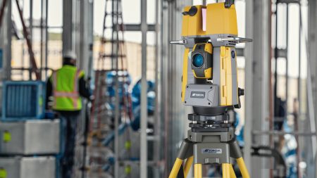
With the intention of offering a powerful instrument for the design of a single operator and scanning in a single configuration, Topcon Positioning Group, introduces the new generation of robotic total stations for scanning: the GTL-1000.
It is a compact scanner, integrated with a total station that contains completely robotic elements. When combined with ClearEdge3D Verity, the instrument offers a new standard of workflows, for verification of the construction allowing a faster scanning.
This robotic solution is designed to take advantage of the prism's tracking and precision, which allows operators to design points with complete confidence in challenging construction environments. It allows operators to start a scan at the touch of a button.
According to Ray Kerwin, Director of Global Product Planning, with Topcon Positioning Systems, operators can perform 360 full-dome scans in a few minutes.
“The seamless integration of the GTL-1000 and Verity creates a complete package that is perfect for construction verification using 3D modeling techniques,” said Nick Salmons, Lead Surveyor for Balfour Beatty Laser Scanning, “The new scanning solution Topcon robotics will increase site productivity by speeding up the construction process or identifying potential design challenges with greater efficiency than previous methods. This new tool will significantly benefit the industrial environment, reducing costs and duration of programs, both for clients and contractors”.
The GTL-1000 also incorporates the MAGNET® field software, designed to offer field-to-office connectivity in real time, and TSshield® for investment protection and maintenance.
TRIMBLE SOLUTIONS BECOME A PART OF THE CURRICULUM OF COLORADO STATE UNIVERSITY![]()
Trimbre recently signed a donation agreement with the Construction Management Department of the Colorado State University (CSU) called "Technologies by Trimble", which will allow the University to expand its leadership in training and research for design. of buildings 3D, construction management, digital manufacturing, civil infrastructure, among others.
As the solutions are integrated ![]() from hardware and software to the curricula, the laboratories of the Department of Construction Management will include products such as Trimble laser scanning, field capture and connection, rapid positioning systems, autonomous units, topography systems, and system receivers. global navigation satellite (GNSS).
from hardware and software to the curricula, the laboratories of the Department of Construction Management will include products such as Trimble laser scanning, field capture and connection, rapid positioning systems, autonomous units, topography systems, and system receivers. global navigation satellite (GNSS).
Software that has been donated includes Realworks scanning, Trimble Business Center, Vico Office Suite, Tekla Structures, Sefaira Architecture and SketchUp Pro, along with specific MEP software. Trimble also plans to donate the hardware its products require, including Field Link and Rapid Positioning Systems laser scanning equipment, UAS, topographic systems and GNSS receivers.
Jon Elliott, Deputy Director of the Department and Coordinator of the Undergraduate Program of the Department of Construction Management - CSU, shared: "Through numerous pieces of Trimble software and hardware applications, students gain significant exposure to cutting-edge technologies. in topography, estimation based on construction and virtual design (VDC), site logistics, 3D modeling, energy performance analysis of buildings, laser scanning, photogrammetry and more. Beyond the applications, specialized Trimble employees will provide exceptional educational opportunities through demonstration and training in the use of the software. Through this exciting collaboration, Trimble is making significant contributions in order to prepare students to relate to a construction industry with advanced and dynamic technologies. "
Roz Buick, Vice President of Trimble said: "Collaborating with the CSU Construction Management Department has been exciting.
Trimble's portfolio is highly relevant to students at the University. It will be gratifying to see the next generation of professional architecture, engineering, construction and construction operators experience the breadth and depth of our solutions that are part of the construction lifecycle. We also look forward to supporting and learning from these new professionals as they experience and apply our solutions to the real world through their curricula."
Taken from Geo-engineering magazine -Junio 2019