
shp
-
Maps

Entrepreneurship stories. Geopois.com
In this 6th edition of Twingeo Magazine we open a section dedicated to entrepreneurship, this time it was Javier Gabás Jiménez's turn, whom Geofumadas has contacted on other occasions for the services and opportunities it offers for the community...
Read More » -
Geospatial - GIS

Transform spatial data Online!
MyGeodata is an amazing online service with which it is possible to transform geospatial data, with different CAD, GIS and Raster formats, to a different projection and reference system. To do this, you just have to upload the file, or indicate…
Read More » -
Geospatial - GIS

CAST - A free software for crime analysis
The detection of spatial patterns of crime incidences and trends is a topic of interest for any State or local government. CAST is the name of a free software, initials of Crime Analytics for Space – Time, which…
Read More » -
AutoCAD-AutoDesk

Introducing Spatial Manager for BricsCAD
We are pleased to note that the first version of Spatial Manager for BricsCAD has been introduced, so users can now use GIS routines on low-cost CAD software.
Read More » -
AutoCAD-AutoDesk
Spatial Manager: Manage spatial data efficiently even from AutoCAD
Spatial Manager is an application for spatial data management, which works independently. It also has a plugin that gives geospatial capabilities to AutoCAD.
Read More » -
Cadastre

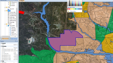
How to open, label, and thematize a .shp file with Microstation V8i
In this article we will see how to open, theme and label a shp file using Microstation V8i, it also works with Bentley Map. Despite the fact that they are archaic 16-bit files, as old as some –many– of my gray hairs, it is inevitable that they continue to be used…
Read More » -
Geospatial - GIS

Free online converter for GIS - CAD and Raster data
MyGeodata Converter is an Internet service that makes it easy for us to convert data between different formats. For now the service recognizes 22 input vector formats: ESRI Shapefile Arc/Info Binary Coverage Arc/Info .E00 (ASCII) Coverage Microstation DGN (Version 7)…
Read More » -
Geospatial - GIS

CartoDB, the best for creating online maps
CartoDB is one of the most interesting applications developed for creating attractive online maps in a very short time. Mounted on PostGIS and PostgreSQL, ready to use, it is one of the best I have seen... and it is a...
Read More » -
Google earth / maps

OkMap, best for creating and editing GPS maps. GRATUITOUS
OkMap is perhaps one of the most robust programs for building, editing and managing GPS maps. And its most important attribute: It's Free. We have all seen ourselves at some point in the need to configure a map, georeference a…
Read More » -
Geospatial - GIS

SuperGIS Desktop, some comparisons ...
SuperGIS is part of the Supergeo model that I spoke about a few days ago, with good success in the Asian continent. After trying it out, here are some of the impressions I've gotten. In general, it does almost what any other…
Read More » -
GPS / Equipment

Posify, low-cost GPS centimetric accuracy
This product was recently presented at the ESRI Users' Conference in Spain, just last week and this next week they will be at the TopCart in Madrid. It is a GPS positioning and measurement system that…
Read More » -
ArcGIS-ESRI

What's New in AutoCAD, ArcGIS and Global Mapper
ArcGIS Plugin for AutoCAD ESRI has released a tool to view ArcGIS data from AutoCAD, which hangs as a new tab in the Ribbon and does not require an ArcGIS license or the program…
Read More » -
Teaching CAD / GIS

2 News in the geospatial area that you can not ignore
The year has started very strongly for companies dedicated to the training area, we take advantage of this article to promote some of the innovation that exists in this area, and in the process we give continuity to a product, of…
Read More » -
GPS / Equipment

What's New in MobileMapper Field and MobileMapper Office
In June 2011, the new versions of the software used in the Ashtech equipment were released, so when buying new equipment, these versions will surely not come installed. I take advantage of this article to indicate where…
Read More » -
Maps

The best of Zonum for CAD / GIS
Zonum Solutions is a site that offers tools developed by a student at the University of Arizona, who in his free time was dedicated to putting code into topics related to CAD tools, mapping and engineering, especially with kml files. …
Read More » -
Maps
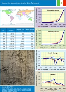
Urban sprawl, 2011 theme
The demographic issue will be fashionable this year –and the following ones– because there is not much to do to address solutions globally. This year's focus for National Geographics is precisely the world population on the eve of being…
Read More » -
Maps

How Mapserver Works
Last time we talked about some criteria why MapServer and the basics of installation. Now let's see some of its operation in an exercise with the maps of the Chiapas friends. Where it is mounted Once Apache is installed, the…
Read More » -
Geospatial - GIS

Version Differences MobileMapper Office and MobileMapper 6 Office
In the last posts we have been talking about data downloaded from Magellan devices, and from there arises the need to clarify about different versions of MobileMapper Office. The MobileMapper 6 Office This is a software, which comes when…
Read More »