
CivilCAD
-
AutoCAD-AutoDesk

Import points and generate a digital terrain model in a CAD file
Although what interests us at the end of an exercise like this is to generate cross sections along a line axis, calculate cut volumes, embankment, or the profiles themselves, we will see in this section the…
Read More » -
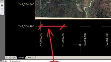
Teaching CAD / GIS

AutoCAD exercises for surveying using CivilCAD and Total Station
This is one of the best tutorials I've seen, especially for CivilCAD users hoping to do survey routines that would take a lot more steps and complexity with Civil3D. The document has been constructed and provided to the…
Read More » -
AutoCAD-AutoDesk

Generate cross-sections with CivilCAD
With this article we welcome the new face of the official CivilCAD site, a great job by the friends of ARQCOM on the eve of its 15th anniversary with more than 20,000 users in Latin America. In its…
Read More » -
AutoCAD-AutoDesk

Generate technical memory of plots with CivilCAD
Very few programs do this, at least with the simplicity that CivilCAD does. What we expect, in general, is a report of the plots, by block, with its course and distance chart, boundaries and use. Let's see how...
Read More » -
AutoCAD-AutoDesk
UTM coordinate grid using CivilCAD
I recently told you about CivilCAD, an application that runs on AutoCAD and also on Bricscad; this time I want to show you how to generate the coordinate box, just as we saw it done with Microstation Geographics (Now Bentley Map). Usually these things…
Read More » -
AutoCAD-AutoDesk

Create alignments in CivilCAD
My previous article explained something about CivilCAD, a quite handy application geared towards both AutoCAD and Bricscad. Now I want to continue the exercise based on our previous Total Station Surveying course, working on the alignment in a digital model.…
Read More » -
AutoCAD-AutoDesk

AutoCAD Level Curves - From Total Station Data
How to generate level curves we have already done with other programs. In this case, I want to do it with a program that one of my best technicians showed me in a training; of which he had known but to which little interest...
Read More » -
AutoCAD-AutoDesk

AutoCAD Course for Microstation Users
This week has been a very satisfactory day, I have been teaching an AutoCAD course for Microstation users, as a continuation of the topography course that we had given a few days ago using CivilCAD to generate the digital model and…
Read More »