
View UTM coordinates in Google Maps and Street View – using AppScript on Google Spreadsheet
This is an exercise developed with students from a Google Scripts course carried out by the AulaGEO Academy, with the aim of demonstrating the possibilities of applying development to the well-known Geofumadas Templates.
 Requirement 1. Download a data feed template. The application must have templates in latitude and longitude with decimal degrees, as well as in degrees, minutes and seconds format.
Requirement 2. Upload a template with data. By selecting the template with the data, the system will alert if there was data that could not be validated; Among these validations includes:
- If the coordinate columns are empty
- If the coordinates have non-numeric fields
- If the zones are not between the 1 and the 60
- If the hemisphere field there is something different than North or South.
In the case of lat,lon coordinates you must validate that the latitudes do not exceed 90 degrees nor that the longitudes exceed 180.
The description data must support html content, such as the one shown in the example that includes the display of an image. It should still support things like links to routes on the Internet or the computer's local drive, videos, or any rich content.

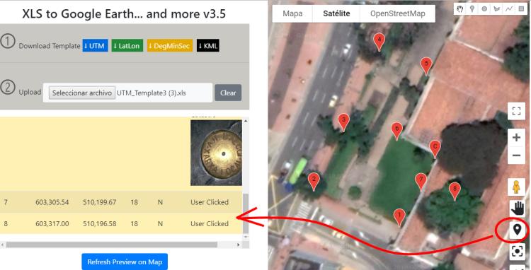
Requirement 3. View the uploaded data in the table and on the map.
Immediately the data is uploaded, the table must show the alphanumeric data and the map the geographical locations; As you can see, the upload process includes the transformation of these coordinates into geographic format as required by Google Maps.

By dragging the icon on the map you should be able to preview the street views or 360 views uploaded by users.

Once the icon is released, you should be able to see the points placed on the Google Street View and navigate over it. By clicking on the icons you can see the details.

Requirement 4. Obtain map coordinates. You must be able to add points to an empty table or one that has been uploaded from Excel; The coordinates should be displayed based on that template, auto-numbering the label column and adding in the detail that was obtained from the map.
The video shows the result of the development on Google Scripts
Requirement 5. Download the Kml map or the table in excel.
By entering a download code you must download the file that can be viewed in Google Earth or any GIS program; The application must show where to obtain a download code with which you can download up to 400 times, with no limit to how many vertices there can be in each download. Just the map should show the coordinates from Google Earth, with three-dimensional model views enabled.
In addition to kml, it must also be able to be downloaded to excel format in UTM, latitude/longitude in decimals, degrees/minutes/seconds and even to dxf to open it with AutoCAD or Microstation.

In the following video you can see the development, downloading the data and other functionalities of the application.


Hello, good morning from Spain.
Interesting application, to have approximate data.
If data or coordinates are needed with precision, it is advisable to use topographic instruments used by qualified professionals.
Then it can also happen that the image is outdated and the data sought is no longer there or has been moved. You have to see the date when Google "passed by there".
Greetings.
Juan Toro
How and where set in Excel file the 35T zone for Romania? For me not working. If i put 35 only show my coordinate nera Central Africa?
Regards.