
Maps on the web, who will be the winner?
10 years ago the lawsuit was for the navigation portals, today without being Google portal that arrived late was left with the traffic, little or nothing remains of what Excite, Yahoo, Infoseek, Lycos and others were.
Now the lawsuit is against Google, in the case of map services they all do almost the same thing, fighting for whoever displays them more colorful and Google continues to gain traffic, not because its maps are more attractive but because every day it integrates more data with an opening not only to the English-speaking market. Google also wins by integrating other toys such as GoogleEarth, StreetView, the available API and especially its search engine.
Undoubtedly, in the end will win the prize that manages to do better business with the maps. Here are some of the map services currently competing:
 |
Map, satellite, hybrid and now terrain view variation. Open API to developers. Progressive business model by integrating it with all its applications, all beta. | |
 Microsoft Live Search Microsoft Live Search |
 |
Able to compete with Google, much more colorful, fewer images but very creative 3D features. |
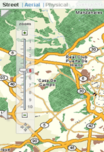
 |
Good at the map level, its zoom control has aids to navigate at the city, state, street level etc. little image coverage, we know Microsoft will make it disappear to bring Live to life. | |
 Ask.com Ask.com |
 |
Another alternative, a search engine that still survives. |
 |
Fairly detailed address, image and hybrid options. Limited coverage in non-potential countries on the web. |
|
 OpenStreetMap |
 |
Free code system, options to edit and collaborate. Creating slowly, but at the rate always of the non-popular ones by being open. |
There are other services that only have local coverage, does anyone know of others with global intent?


