Dynamic Maps with Visual Basic 9
The 2008 version of Visual Basic, seems to be a complete contradiction between its high capacities and the life time that has been considered.
 In an article published in Msdn Magazine In its December 2007 edition, Scott Wisniewski, Software design engineer at Microsoft, shows an outstanding job as a tutorial on how to draw maps using Visual Basic. With this it demonstrates not only some of the most attractive features of Visual Basic, but also offers a working example that could be used as a basis to add to other developed applications.
At the beginning of this post we made reference that this contradicts what many long ago assumed, that Visual Basic was on a death line. The suggestion of this premise is based on that crazy habit of Microsoft to abandon platforms to maintain its sales; after his effusive push towards .NET and C (Sharp) in his desperation to compete against Java.
We know that the limitations of Visual Basic, in being very exclusive to the development on Windows platforms would have to be replaced when the Win32x environment died, Microsoft enters into force with .NET and changes its strategy of dynamic liberations (dll) by the framework Under the line that brings C ++; So it was expected that Visual Basic would die of a crash ... it seems that it will happen in the long run, when Windows Vista is installed (year 2014 :))
If history repeats itself, Visual Basic and .NET will happen just as Microsoft did with Fox to extend the life of SQL and Access. Although the competition is not as it was then, the trends of multilayer design and web integration are the detonators that will make Visual Basic collapse or mask.
Well, it is worth taking a look at the development proposed by Scott, although we recommend Read the full document We will make some comments that for the size of the post force simplism.
1. Using WPF Environment

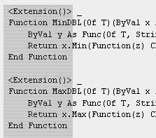
Let's admit, the article is very well elaborated and abstracted, especially if the credit does not belong to an editor but to the developer himself; explains how the wPF (Windows Presentation Foundation) environment can translate what we used to know as "objects", under a broader concept of "geometries", which can be associated with dynamic code... we are left wondering if this is only for programming purposes. “view” like flash maps, or geometry is reconstructed on the fly from a database.
2. Application Object Model
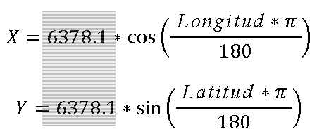
The author goes on to explain how he configured (reinvented) the form of data deployment ... very creative in his  Conception of Map, region, polygon all under Dependency Objetct and worrying in the sense of literally reinventing what spatial applications already do in basic functionalities such as zoom, pan, xtent. We would be concerned if new mapping platforms wanted to be developed based on these functionalities, due to the waste that would exist in pure code reinvention, considering that this field more than programming requires adaptation of well-documented cartographic, geodetic and now geomatic concepts, but that each time you want to reinvent systems are ignored. So we do not criticize creativity, rather we take our hats off to someone who develops something and wants to share it so openly, however we remember the imminent need to standardize and systematize what has already been achieved.
I bring up a phrase I heard a while ago in a meeting:
... we are looking to make a Brazilian ArcView ... jo ...
3. The use of Map Classes
 Here, in a very creative way, the author links the polygons with the North American federal standards known as FIPS, although these are used only for "statistical" purposes, it seems to us that the boy has smoked a good job. He says it right, the “region” properties will be externally editable.
4. XML data management
Finally, I assume that after thinking and drinking coffee you have decided to go for an (almost inevitable) xml and LinQ structure to import data and geometry in a structured way, although here you run into the limitation of this complex field, geodesy. This shows that reinventing in this sense is dangerous, if the purpose of the result is not very clear; it seems to us that the work he has done for purposes of “See results” is very good, the worrying thing is when this result is seen by an executive in a meeting and says:
“I have contact with shareholders who are willing to invest in this application so that we can make a mapping system that can be implemented in the Mega Institute of Territorial Management…”
And give it, they end up reinventing something ... that Scott admits in his non-geomatic language:
“For the complex geometries, what I did was make two figures, first I showed the one in the background so that the one in the front would not be covered and thus it would look like an island…”
5. Necessary conclusions
Finally, for our programmer friends we recommend the document, because it shows how it is possible to build map applications without using third-party codes ... we thank the author for his kindness and clarity, concluding at the end about what he expects of this:
In essence, using Visual Basic, WPF, Expression Blend and LINQ I was able to develop an application capable of re-creating relatively sophisticated visualizations from an existing data body. This application could easily be extended to view data from different years or to manipulate data in different ways. All code is available with the download of this article, so Do not hesitate to experiment And see what you can get.
Street: Geomusings