Istanbul Water System wins BE Award in Geospatial category
Istanbul (Istanbul) The city of Turkey, which shares its metropolis between Asia and Europe, known in the Byzantine / Greek period as Constantinople, currently with about 11 million inhabitants, has a system certified by several world quality control standards. Waters.
 This year the implementation of technologies to manage its water system has been the winner of the First in the BE Awards in the category Water resources management within the geospatial line. Every year, He Bentley Institute makes its award to the innovative ideas that use the geo-engineering products of the Bentley line; This is done at the annual conference that this year has been in Exton, Pennsylvania where they have chosen the winners among 280 nominations.
The categories are always:
Construction, Civil Works, Plants, Special Awards, Academic Awards and of course Geospatial.

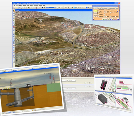
The project ISKABIS developed and implemented a complex system on the Visual Basic platform that is integrated in the CAD tools of the Microstation line. The products they used are:
- Microstation For general mapping and VBA development
- Geographics For project GIS management
- PowerDraft For economic licensing of users
- Water, Wastewater For the hydrosanitary system
- Descartes For advanced image processing
- Inrods Site For the geometric design of roads.
The final deployment allows system administrators and users an attractive control and visualization (of maps, raster images and animation in three dimensions of the buildings and the entire hydrosanitary network of Istanbul).

Although they were short, perhaps a next phase should be the integration of web services.
Many criticize this type of award, considering it a way to slap those who spend their money buying products as ESRI does, although I will be honest ... The time to receive these awards is gratifying


Thank you
I want to know this program thanks