Virtual Earth
Virtual Earth updates images, including Hispanic countries
 The update of high resolution images of Virtual Earth this July is going quite well, it has been a long time since we have seen such massive amounts updated, including Spanish-speaking countries. It seems that his offense It has worked for finding data, although most are taken with UltraCam, which is owned by Microsoft.
Let's look at something from our environment that has been updated:
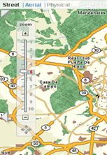
| Spain
Obviously, it goes for the online business |
|
| Central America
Strange choice ... and Mexico? |
|
| South America
... or tickle ... |
|
| Portugal |
|
| Other countries | Australia (the whole country !!!), United States, Belgium, Denmark, Finland, Germany, Ireland, Norway, Spain, Sweden, Switzerland |
| Other places (Satelital image) | Lithuania, Albania, Morocco, Slovenia, Kazakhstan, Georgia, Russia, Montenegro, Nigeria, Iran, Cyprus, Greece, Luxembourg, Northern Ireland, Hawaii |
If this continues, it is likely that it will reach popularity among our countries that continue to worship Google Earth, although you should consider working a desktop tool that is one reason why GE is still in command.