UDig, first impression
We have already looked at other tools before. open source In the GIS area, among them Qgis and gvSIG, apart from  Non-free programs that we tested before. In this case we will do it with User-Friendly Desktop Internet GIS (UDig), One of those who come in PortableGIS.
Where does it come from
uDig is a construction of the company Refractions Research, Who after winning a major award sponsored by GeoConnections, they invested in this and other developments. UDig is licensed under GNU LGPL, The same company is owed the development of PostGIS And significant contributions to Geoserver.

Features
It is an exquisite development, breaking many conventions of traditional tools, with a face similar to QGIS.  Among its characteristics we can mention:
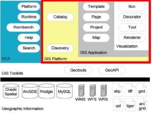
- Built in Java, under the Eclipse environment (As gvSIG)
- The freedom to configure the interface is enviable, being able to drag windows almost anywhere, execute them in the background, external and internal drag, minimize them to buttons and freely modifying the edges of frames.
 The execution speed is very good (despite being on Java, I have tried it from a Acer Aspire One, With Windows XP); It runs on Linux and Mac, obviously with better performance.
 - As for reading vector formats, it is limited with discrete files (Does not read dgn, kml, dxf, or dwg) but the smoked ones (gml, xml) are. The only traditional one who reads is the Shape file.
- With raster images it also has its limitations, but you can paste it to wms services and other online services.
- As for databases itself is robust, ArcSDE, DB2, MySQL, Oracle Spatial, PostgreSQL/ PostGIS and WFS, so through some of these can integrate the vector data that does not access conventionally.
 The grid, scale bar, and legend are integrated as if they were layers. This is interesting because they are not functionalities of the display interface but of the data. Although its configuration is somewhat complicated (On first impression)
 - It has features that make it practical, such as:
-copy / paste de Features (as Manifold GIS)
-paste as xml en notepad
-Very practical thematic symbology, with alerts for Avoid problems with color blinds, CRT monitors, projectors, LCD monitors, color printing and photocopying.
 - Interestingly, the tool usually comes with a structured example, which includes a Canadian community and a global base of cities, countries, time zones, and satellite images. This strategy is very good to understand its capacity at the moment of seeing it for the first time, something that other programs that download, install and generate the big question should take into account:And now that **** I do with these buttons?
- Checking for updates online is another handy feature that other projects should consider. In this, somewhat similar to gvSIG, there is a barrier in the first impression, and that is that the wealth that is in the extensions does not have enough marketing or it lacks a common thread that promotes its usefulness (and in that case officiality). At least, with this online update (which gvSIG does not have), after a few minutes of downloading I can see many capabilities that it receives in the Grass extensions, JGrass, SEXTANT, Horton Machine And Axios in hydrological applications, 3D models, GPS, raser and vector interaction.

Disadvantages
 uDig does interesting things, just like qGIS is complemented with JGrass, but as a GIS solution Is not the best open source tool, In terms of vector construction functionalities and topology management, QGIS (With the extensions it brings) and GvSIG (without extensions). Although it is mature, and has what a common user might require, its potential is for the user with Java development capabilities; your focus Internet GIS It makes sense to connect to data and search for updates but as far as publishing has little to offer (Geoserver does).
Read few CAD / GIS formats, Has failed to integrate the community at the That gvSIG, And in this the demand of users and strategic alliances are an important engine to accelerate the development, aspect that does not appear be achieving in the impetus of gvSIG (yes at the level of Canada, but not globally).
The fact Break schemes It makes you lose a couple of points, as many users become out of control at the beginning (in the management of projects, catalogs and perspectives).  Recover these points For simplicity Which has once known its way of operating, although in the philosophy of Java scalability we must take care of the balance so that the basic version more extensions (which makes sense) does not look (in its free evolution) to a Christmas tree To which hangs so many figurines that one day we lose, or harmony, or symmetry, or timeline.
Not be so well known Is a big disadvantage (that happens to many others), being a solution for a group of select is not long-term guarantee, not in applications open source; Consequently, little Systematization Of experiences and documentation, although its protocol for making new decisions is admirable. For a municipality, uDig could be a very functional solution, but getting support and training can be Problem Complexfar from British Columbia); It looks much more practical For projects that will involve personalization and that they will have a budget to support it (eg, environment, vulnerability).
Apart from the potato project in Peru and what Axios reports, little has been heard of uDig in the Hispanic environment; The continuity of solutions of this type at the country level depend on the application of policies Of migration towards free software, a topic that is very slow in Latin America.
The biggest disadvantage I see to uDig is Sustainability in the long term, The fact of being a tool supported by a private company creates doubts in questions such as:
- And if Refractions Research says one day that the costs of continuing support and development are unsustainable, who will?
- Can the community created serve a dynamic of global growth, if there is a high demand?
- Are there no other Java / Eclipse projects that do the same thing, which are Open Source, Which seems to double efforts?
- Does not it seem that the Free tools are strategies of companies that finally leave captive support?
Sure that mara Open Has very clear answers to the above, but it is not bad to think about sustainability, which in itself is complicated in free projects, because if we separate the technical and technological aspects that seem to be clearly working, the financial aspect Is questionable in the long run. Today we live in times when a hurricane collapses the world economic system, a Shoe In a conference can trigger a war that in a single day ends with the good omens, the fall of the bag below the acceptable makes big companies go To hell in less than an hour.
These things, we are led to think that before so much range (And yes it is so) of solutions that give complete freedom to man, the dispersion of efforts and money is in danger (because ultimately that costs). Freedom can become so much that one day it can be used to abandon projects due to decisions made by others who were not founders of the original idea. In this regard, surely many have already written, but we must continue to think about it carefully, remembering that one day investments will be measured by the impact and not by the geofumada.
Conclusion
- As a development: very robust and practical, other projects should imitate ideas here.
- As a solution: it has great limitations when comparing it with others of its level, (in a first impression)
- As a project: he walks very slowly and does not seem to be in a hurry.
- As you try the extensions, we can give you the points that add after the first impression.


JRE6.
But I've already solved it by copying the sqljdbc.jar to the JRE lib \ ext folder.
Thank you as well.
Very good your blog. Congratulations.
And which version of JRE are you running?
I clarify that I have installed version 1.2 of uDig in XP. In case that helps ...
I just installed uDig and I liked it.
The only thing I dislike is that I do not know how to access a BD sqlServer 2008. When I do:
add layer -> DataStores–> MS SQL Server
I get a warning that says: "This factory is not available, usually indicating a missing JDBC, or imageIO-EXT not being installed in you JRE".
And they are both installed and running with GEOSERVER. Is it a question of path to the installation of uDig? In GeoServer you have to move some libraries to a particular folder. And in uDig?
If anyone has any clues, thank you for helping me.
regards
Yes, of course you can.
Even SQL Server 2008 already includes space support.
Are you able to connect to MS SQL Server 2008?
regards
It's Java. Check this link.
http://udig.refractions.net/developers/
Very good your contribution, of pure chance you will not know that programming languages supports to extend their capacities? It's that I'm doing a geomarketing study and I'm interested in programming in a GIS
Thanks for the contribution, here I leave the link
http://www.diva-gis.org/
Diva runs on uDIG! There are few extensions for climate and bioclimatic modeling like this one. It is a project to which other organizations are joining, which in a certain way guarantees the future of it.
Yes, you're right, there are interesting extensions, such as Horton Machine, which includes very interesting digital models and hydrological applications; and, with those of SEXTANTE, Grass and JGrass come many raster and vector functionalities.
I have made some short adjustments to the post, but we will see in other posts when we make use of extensions.
You have barely limited yourself to commenting udig. with extensions earns a lot