
TopoCAD, more than Topo, more than CAD
TopoCAD is a basic yet comprehensive solution for surveying, CAD drawing, and engineering design; although he does more than that in an evolution that has taken him more than 15 years after his birth in Sweden. Now it is spread around the world, in 12 languages and 70 countries, although it does not seem to have achieved a high market segment.
TopoCAD is the star product of the company  Chaos Systems, which also has RhinoCeros, a program for 3D modeling, robust but without much to talk about (this time). Also exists Chaos Desktop, a document manager, similar to what ProjectWise does. Although more practical, with integration to Microsoft Outlook and facilities to associate documents and metadata; for TopoCAD products it has a viewer, while formats like dgn, dxf and dwg can be viewed as images.
TopCAD
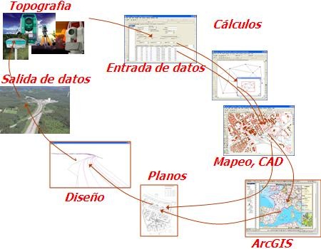
The concept of Chaos solution, through TopoCAD is very interesting, because its name falls short; Its applications range from data acquisition, correction and adjustment, CAD drawing, integration to GIS, engineering design and the cycle closes in the possibility of sending the data back to the surveying team.
Like any other, the line has a reader version, with the variant that a plus can be included to import and export to dwg / dxf formats or interact with surveying instruments. The rest is a modular range, they can be formed into packages between topography and design or they can be acquired independently to taste, according to the roles that are clearly established in the model:
From the field to the desktop: Topography / CAD. The package called TopoCAD Base includes COGO, it can connect to surveying equipment, it can make traverse adjustments using the least squares method. It can also operate terrain models (DTM and TIN),  including what your results imply, such as contour lines, profiles, volume calculations, and cross sections (not the layout). As a CAD tool it has everything you could demand, with precise construction commands, being able to call reference or import common formats such as dwg, dxf, dgn, landXML and shape files. However as a top format, it can handle many attributes within the same map, similar to Xfm of Bentley Map. Also the Base module includes reader of layouts (sheets) and reader of attributes of database or metadatos of Chaos Desktop.
From the desktop to the Database: GIS / Maps. It happens that the top format is not a simple CAD with attributes, but its xml schema stores information that can then be sent to an ArcGIS mxd, converting the tables and attributes as they would be seen in TopoCAD. It can also interact with databases via ArcSDE.
 You can export to common formats such as kml, Mapinfo or spatial database. Recently the FDO connector was launched that allows interaction with open standards data such as MySQL, PostGIS, Oracle, MS SQL Server Spatial, SQLite, ESRI ArcSDE, SDF (Autodesk MapGuide), ESRI SHP, ODBC, WFS, WMS, GDAL (Geospatial Data Abstraction Library) (Raster), OGR (Vector format: shp, gml, dgn, kml, mapinfo, etc.).
From Desktop to Plotter: Plans / Maps. It has a great ability to create layouts, called sheets, with tables of data extracted from the attributes. 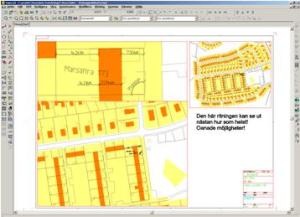 Vector objects, both lines and figures, dynamic elements, with which operations can be done from the layout, for example, the text sizes in the model can be adjusted from the layout without much turning. Supports sketch-type work, as if to release artistic taste on a final product.
From the desk to Design: Engineering. 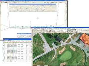 It includes capabilities for geometric road design, as Civil 3D or any competition would. It also has something for design of railway tracks, tunnels, pipes, canals and levees.
The way the data are handled, for example the cross-sections is more dynamic than the common, there is interaction with both the alignment in plant and with the profile generated.
From Design to Field: Topography / Stakeout.  The data of a design can be exported to files that the total station or GPS can use to operate. It does not matter that the data was converted to UTM on import, then it can be exported as planar coordinates to avoid damage due to projection settings. And then this cycle can be repeated over and over again.
Conclusion
Overall, I find it an interesting tool. A CAD with mapping, design and interaction with the topography capabilities. The base price starts from about $ 1,500, depending on what is added.
Here you can download A trial version of TopoCAD


Yes, it is a very good program.
A pity that there are no distributors in America. In Europe and Middle East is where it is well positioned, according to its distributors page.
http://adtollo.se/en/company/resellers/
It is very interesting for its application in engineering, I would like to learn about this program but in Peru do not dictate about this software as I could acquire more information about this
José Carlos
I am Geogafo, I give class, I graduate 1981 and during my study, these programs did not exist so useful today.
I would like to have access to this program, with all its applications, without restrictions, to learn its benefits, applications etc., and to compare them with other similar programs. Thus, to give the members of the course, a vision to integrate these tools, contributing to a better teaching and better use of academic time.
Thank you in advance for the kindness and collaboration you can give to this communication.
The version I'm using is Topocad 7.2.1
regards
It is a good program I have used, it has many advantages
If someone would like to exchange let me know I'll know
DCA
better to know several than just one ...
Besides they are all bullshit
I believe that in Portugal there is no representative, but in this page you can see the ones of other European countries, if you are useful you can contact them
http://adtollo.se/
Hi, I'm interested in buying software where I can buy it in Portugal?
You can find out about TopoCAD in this email
Info@chaos.se
Good morning, I am very interested in acquiring a Software to work in topography and civil engineering, capable of generating volumes, cross sections, design of roads and quarries, work with Eagle point the volume part for its reliability and gender level curves in Civilcad for its speed, that is, I work with several Software to develop a job, but I would like to work with only one that gives me reliability and agility in my work, I want to know its price and how to acquire it thanks for the attention paid