Land Governance: the LGAF methodology
It is known as LGAF, to the methodology that in Spanish is known as Framework of Evaluation of the Governance of the Earth.
This is an instrument with which the diagnosis of a country's legal status is made, in terms of legislation and practices related to public policy specifically with the possession and use of land. It is promoted by the World Bank and FAO, among others; It is generally applied in countries where land administration modernization projects have been promoted, based on the presentation by Klaus Deininger, Harris Selod and Tony Burns in The Land Governance Assessment Framework: Identifying and Monitoring Good Practice in the Land Sector.
The steps of the methodology of Earth Governance
One of the potentialities of this exercise is that it allows through analysis, panels and follow-up agreements, to involve experts and technicians diagnose five basic areas:
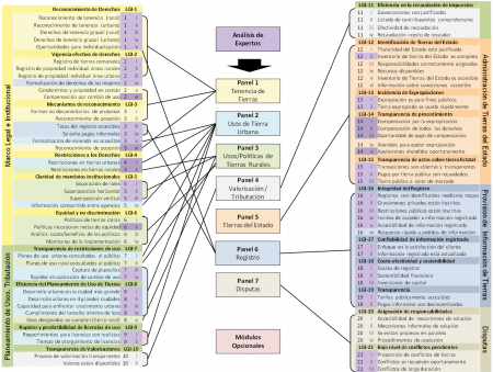
- Legal and Institutional Framework
- Land Use Planning, Land Administration and Taxation
- State Land Administration
- Provision of Land Information to the Public
- Dispute Resolution and Conflict Management
Each of these areas has a series of milestones, concentrated in 21 land governance indicators, broken down into 80 basic dimensions with which it is possible to gradually identify the progress, bottlenecks and actions necessary so that integrated territorial management can be a fulcrum for development. Additionally, two more modules are applied, which are generally linked to projects where the regularization process has reached necessary stages in the conformation of the legal framework:
- Large-Scale Land Rights Acquisition
- Forestry
The document can be downloaded from the World Bank website, in different languages. However I leave it In Scribd which is why very useful documents end up in a broken link over time. In general, the manual provides a systematic guide to coordinate and implement the Earth Governance method, details the requirements for recruiting experts, provides instructions for preliminary data collection, organization of expert panels, and implementation. of semi-structured interviews and provides a format for organizing the results.
Much of this exercise may seem poetic, for the technicians who are called upon to identify how they do things, why, and how it could be better; especially since the administrative / state issue is usually the point of greatest weakness in an area where geomatic research and development has reached surprising levels. But in the end, it is a necessary drink if we want the points captured in the field to end up in public policies that produce wealth and improve the living conditions of the inhabitants.
Territory management in public policies
I hang the document here, since its usefulness is of public interest, while recommending my best reading suggestion: "Why nations fail." The reason why I suggest the joint study of the two instruments is because we geomatists are not very given to studying Economics, and this is one of the ones that has been highlighted the most, where the subject will seem familiar to us. The book (Why Nations Fail) is by Daron Acemoglu and James Robinson, in a masterful position based on examples, on how the vision of the territory for public policy decisions can be a decisive factor for a nation to succeed or fail.
It is likely that reading at leisure will inspire us with a good marijuana cigar, if not ours, from the authors of these contents. But beyond the joke, it is likely that reflection makes us think that on this issue there is much to do, more from the good practices of others than from the reinvention of what has already been tried.
- Little benefit is given to the settlers, with a title deed in their hands, if the quaternary sector (government) moves very slowly in modernizing the administrative career of its officials.
- A smoked study of Land-use planning, Can finish in some maps painted on the walls of a municipality, if they are not accompanied by development plans that indicate in a simple way how with their resources can be reached a vision of the territory.
LGAF_Manual Implementation_Spanish_Complete_2013_03_04b - copy.docx by G_Alvarez_
How the Earth Governance diagnosis (LGAF) is implemented
For now, I will be working on some spaces of a process to be developed in this section of the UTM 15N Zone. So I hope to talk about it from time to time, and feed in a practical way what may be of interest to readers who like democratized knowledge.