
The 7 principles of the multilayer model

Although it is easier said than done, I would like to start this week Geophysical On this subject, although there are complete books on this subject, we will use 7 Web principles 2.0 to summarize the scheme of the multilayer model and apply it to the geomatics field.
The concept known as multilayer, emerged after client-server applications took a boom, linked to the growth of the Internet at the same time that private networks (Intranet) also became popular. One of the most important objectives is that the development does not affect the operation, much less the query users in a system that is in constant use.
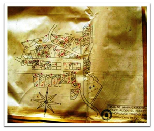
Such is the case, for example in a massive cadastre project in which field technicians, mapping or digitizers must feed the information; then the legal analysts, GIS and regularization technicians must process the data while from the side of external users there is a demand at the level of consultation or requests for online procedures.
Let us see then the layers of this model and its principles.
The development layer

 1. Simple design. It is important to understand that when multilayer applications are developed, functionalities that will slow down the process, data deployment or update of functionalities cannot be exaggerated. This is the reason why the use of Javascript-like procedures running on a server allows many users to execute tasks at the same time without reloading the system. As the processes can be made smaller, it only requires monitoring the number and capacity of processors to keep the design simple ... although this more than being a specialty of software architects seems to be more of a skill of the gods.
 2. Applications for multi-device use. It is necessary to consider that users will want to access information from desktop devices or a variety of mobiles via the web, so development must consider this principle. Although it is not easy to predict the evolution of the well-known gadgets, at least the specialty of the project should be considered for the purposes of feeding and downloading data, as in the case of a cadastral process, the use of GPS equipment and PDA's with GIS applications / CAD with minimal tabular data feed capabilities, and use of raster / vector data. As the specialty of the business is diversified, it is necessary to be aware of the advancement of technologies.
 3. Via Database. To keep a processor free from collapse, it is necessary to consider that any action that the user executes is a simple call to the database, so if file transfer is used, it is preferable to create web services. If maps will be used, the ideal is to create IMS services for publication and if documents will be downloaded, look for the use of web services.
The Process layer
 4. The web as a platform. Be it Intranet or Internet, the concept is the same, looking for the users' work environment to be online, so any type of processes run from the server. This is complemented by the following principle, since the intention is to ensure that the operation of processes does not require equipment with large resources, although it is necessary to redesign desktop applications.
 5. Using online applications. This is a great challenge for developers, since this layer also includes a level of users who carry out processes that go beyond the query. Such is the case of cadastral maintenance, which requires the use of discrete files and not only manipulation of tabular data. For this, the chosen software must provide a controlled file management environment, versioning and the process known as checkout-checkin; The API is also expected to provide capabilities to customize functionality and prevent desktop processes from complicating synchronization.
The User Layer

 6. Collective intelligence. This principle comes from the concept of community, very popular these days. It is important to create interfaces that facilitate communication between users, be it these forums, support networks or instant messaging channels, so that users can share their doubts, solutions and take advantage of collective skills.
 7. Feedback. The services created must have sufficient functionalities so that users can report errors, add comments are automated or voluntary. The important thing is that the users who manage the other two layers know about the visitors. Restricted access, functional registration, and automated change updating are also expected at this level.
These principles should influence the moment to decide for a brand of software, mainly because the life of this is not in the products of exit but in the capacity to put him developing hand.


Thank you for your information, thank you very much.
Very good article helped me a lot!
Greetings!