
OpenGeo Suite: A great example of GIS Software thinking about the weaknesses of the OSGeo model
To this day, at least in the geospatial environment, every professional with neutral thinking recognizes that free software is as mature as commercial software, and in some respects superior.
The standards strategy worked very well. Although its balance of updating in the face of the energy required by technological evolution is questionable, perhaps it was what laid the foundations to guarantee success in other efforts such as the community, philosophical approach, economics and other ideas that were used to justify the model. which are ultimately also necessary.
However, selling Open Source solutions is not easy in business or government environments, for many reasons that partly originate from the competition but also as an inevitable result of the weaknesses of the model, which must evolve and coexist with proprietary software. Decision makers ask themselves questions like:
-
If one morning we see a problem resulting from updates from other platforms, in aspects such as security Who responds to the moment we need support, and at what price to leave it budgeted?
-
Given the range of language alternatives, libraries, client solutions, web solutions, what combination should we choose to ensure compatibility? quasi total?
OpenGeo Suite is a solution that not only takes advantage of the full maturity of the available tools, but also aims to respond to those weaknesses in the model. In addition to giving the community a solution with which they can enhance their development initiatives, it creates a common thread for the components involved to guide their evolution and, for companies, OpenGeo Suite provides the seriousness required to decide on open source. Although there are other companies, after a time of testing this alternative I have no choice but to recognize the high capacity and creativity of the thinkers behind Boundless, the company that created this solution.
Let's take a look at the OpenGeo Suite approach:
What tools does OpenGeo Suite include?
Having so many solution options is not bad, it is normal, although it somewhat complicates how to ensure the selection of tools in integral production processes. A wrong selection can be costly if we realize when we have already invested efforts in research, development, training and above all non-recoverable time.
For example, only in terms of development language we have a puzzle resulting from the needs of the community, many of them doing exactly the same, others emulating in another flavor, some with unique characteristics in simple routines that we would like to have all of them. Let's see this separation by functionalities and languages; Although I must be honest, the categorization is not exclusive and in some cases it is difficult to distinguish the border:
- At the client level, which is the most popularized context, are: QGis, Grass, ILWIS, SAGA, Kapaware, based on C ++. gvSIG, Jump, uDIG, Kosmo, LocalGIS, GeoPista, SEXTANTE, based on Java. MapWindow for its part on ActiveX based on .NET.
- In libraries we have: GDAL, OGR, PROJ4, FDO, GEOS on C ++. Java-based GeoTools, WKB4J, JTS, Baltic. NTS, GeoTools.NET, SharpMap over .NET.
- As for solutions for the web, which today are having a lot of popularity: MapServer, MapGuide OS on C ++; GeoServer, Degree, Geonetwork on Java. OpenLayers, Leaflet and Ka-Map in Javascript, mapFish in Python, MapBender in PHP / Javascript.
- As for data bases, Postgres is the dominant indisputable, although there are other solutions.
The above shows us that it is possible to mount a system in almost any environment. Moreover, many of them, although they were born in one language, now support others. Many of them were also born as clients but they are capable of managing web data and in cases such as Open Layers it is even possible to develop in a web environment almost everything that is done in a client tool.
What combination of free software use?
OpenGeo suite was decided by Qis As a desktop client, you already deserve a category of articles on Geofumadas by now. For the web, they chose GeoServer as a data server that operates on Tomcat, Jetty as a Java runtime environment, GeoWebCache for tessellation and OpenLayers as a library, although this last option does not have a mandatory registration, considering solutions such as Leaflet that is growing with great success, especially due to its model based on Plugins and its potential with mobile applications. See that you could go by a single line of language but I would like to see the matrix of analysis that has led you to this definition.
Let's be clear, anyone can implement these solutions individually. What OpenGeo contains is an installer with versions of these components with improvements to make tedious routines more efficient; for example:

 The installer makes the assembly neat. Being able to choose which components to install, remove or uninstall. For those who have dealt with a Java runtime engine with the happy Error 503 will know the usefulness.
- There are different installers: Windows, Mac OS X, CentOS / RHEL, Fedora, Ubuntu, and Application Servers.
- The recent version 4.02 brings PostgreSQL 9.3.1, PostGIS 2.1.1, GeoTools 10, GeoServer 2.4.3 and GeoWebCache 1.5; and supports OpenLayers 3.
- In the start menu you create direct links to stop or start GeoServer and Postgres; Also to raise the user interface of data loading shapefiles to Postgres (shp2psql) and also to access the PostGis database (PgAdmin).
- Also in the start menu there is an access to the localhost, which in this version eliminates the client interface of version 3, with a clean control panel towards the GeoServer, GeoWebCache and GeoExplorer services.
- This product, GeoExplorer is an impressive development of Boundles based on GeExt that acts as a data viewer for GeoServer, allows the uploading of data from a local file or from a data warehouse, being able to configure color, line thickness, transparency, labeling, including rules and saving directly to the geoServer style file (sld). Nobody in their right mind works this one to pure code and GeoExplorer is an excellent solution -Although it does more things-.
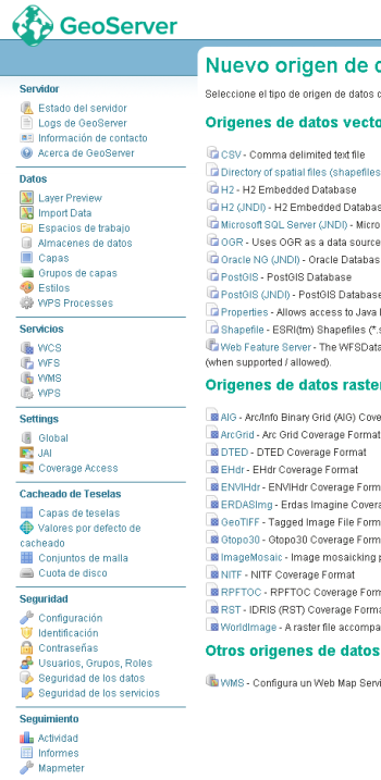
- The installed version of GeoServer includes a link to the import of data, being able to create origins from local shape layers, including PostGis with which data can be moved from one base to another included from the Localhost to a hosted service; It is interesting that this data upload solves OGR2OGR problems that, unless they are done with the console line, throw up difficulties when uploading a multipolygon layer, since the default is simple polygon.
- In this case, the WPS services appear because in the option to install I decided to integrate them.
- GeoServer Add-ons such as CSS Styling, CSW, Cloustering and support for GDAL image libraries can be added at installation time. There is also an Add-on for PostGIS that supports point clouds on the database and GDAL / OGR can also be installed as a client. For developers there is an option to install Webapp SDK and GeoScript.
- Unlike in my version hosted on the server, I see that there are more possible data sources, which can surely be added but in the case of the version that comes with OpenGeo Suite it brings comma delimited text, H2, H2 JNDI, SQL Server, OGR, Oracle and a handful of possibilities in raster backgrounds.
What about Qgis?
- Of the best, for Qgis they created a great plugin called OpenGeo explorer with which you can interact with the Postgres database and also with GeoServer. From here you can edit the slds, move layers, layer groups, edit names, delete, view workspaces, cached layers, etc.
- If a layer is deleted, the sld is deleted; All this is configurable and in the end gets a job from the client controlling what is up, that synchronization can be using the REST API.
- For now, what it does not have is shp2psql but I'm not surprised that it is integrated into the same panel, maybe as transparent as the Spit plugin, which unlike the UI stores the connections, you can upload several layers in block, the progress bar is more Realistic and most understandable error messages.

With this OpenGeo Suite is not saying that this is the magic recipe. But it will surely move a large part of the community to this preference, especially since companies that sell courses will prefer to teach this route that guarantees a shorter learning curve.
The combo is compatible with other tools that can be mounted on the server.
What impact comes with OpenGeo Suite
We will see what impact this has on the community, because behind Boundless there are people with a lot of experience in the field, who have been involved in the development of tools and libraries that now make the sector sustainable. But above all with training in entrepreneurship and marketing services, which is often wasted from the technical level. To mention at least six:
-
Eddie Pickle and Ken Bossung, founders of IONIC, which bought ERDAS on 2007 and is now owned by Leica.
-
Andreas Hocevar and Bart van den Eijnden, who were immersed in the development of OpenLayers 2 and GeoExt.
-
Victor Olaya, who left us that legacy of SEXTANTE,
-
Paul Ramsey, of the early initiators of PostGIS.
The other positive impact is in the formality of a large company, which, apart from becoming a monster in the market - which is always a risk - provides a formality for competition against private sector companies in aspects such as support, credibility, security and Quality control over developments.
The services offered by Boundless, ranging from platform migration to annual support services, seem to us consistent with the business and institutional market that little by little understand the difference between having local support and business support. This market should not be easy, but we see with good eyes how institutions mature in thought, valuing software development and information as an asset, thus they managed to go from assigning auto mechanic tasks to their motorists, to hiring specialized insurance and services of the distribution companies.
![]() In the open source model, there is opportunity for everyone. So what Boundless offers is there, with an opportunity to To be a partner; beyond the ability of those who wish to enhance their ability to sell services in terms of implementation, training, support or development. The example seems valuable to us and of good lessons to learn and complement the effort carried out by the gvSIG Foundation in another way, about which we will speak on another occasion.
In the open source model, there is opportunity for everyone. So what Boundless offers is there, with an opportunity to To be a partner; beyond the ability of those who wish to enhance their ability to sell services in terms of implementation, training, support or development. The example seems valuable to us and of good lessons to learn and complement the effort carried out by the gvSIG Foundation in another way, about which we will speak on another occasion.


Interested in software developers under Opengeo Suite to apply geospatial control to megaproyectos viales
Thank you very much for your editorials. To me personally, I find it enriching.
Your help is important for my analysis and decision-making.