
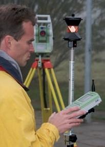
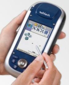
Mobile Mapper 10, first impression
Tras purchase from Ashtech by Trimble, Spectra has begun promoting Mobile Mapper products. The simplest of these is the Mobile Mapper 10, which I want to take a look at this time.
The Mobile Mapper Pro, CE and CX versions ended there although the latter is still on the market; From Blade technology was launched the known Mobile Mapper 6, which is the predecessor of this one that we are now presenting. The line is different, because an MM6 despite having new technology in terms of operating system, does not surpass the Mobile Mapper Pro in terms of receptivity, that was a very fine receiver with the ability to read the C / A code and the carrier phase. The post-processing was standard and its final cost with a good haggling was around 1,200 dollars with post-processing. While the MM10 still only reads the C / A code and with technology (at the software level, not reception) it manages to reach 50 cms of post-processing; As long as the post-processing is activated, but this option costs an additional $ 500, that is, it comes out as 1,900.
How the Mobile Mapper 10 differs from the Mobile Mapper 6
 In general the differences are significant. In terms of design, the MM10 is taller, wider, but also narrower; with better distribution of space; We never knew what the broiler pan on top for. It has rubber bumps on the ends that make it easier to handle with one hand.
The lower box shows in green the aspects that give the Mobile Mapper 10 greater potential compared to the MM6 and those marked in red are the negative differences that are unavoidable in the face of change. I am also placing a column to show what happens with the Mobile Mapper 100, Of which I spoke earlier.
| Mobile Mapper 6 | Mobile Mapper 10 | Mobile Mapper 100 | |
| Constellations | GPS, SBAS | GPS | GPS, GLONASS, SBAS |
| Outdated | 12 | 20 | 45 |
| Frequency | L1 | L1 | L1, L2 |
| Actualización | 1 Hz | 1 Hz | 0.05 seconds |
| Data format | NMEA | NMEA | RTCM 3.1, ATOM, CMR (+), NMEA |
| It can function as a base | No. | No. | Si |
| SBAS mode real-time precision | 1 - 2 mts. | 1 - 2 mts. | less than 50 cm .. in SBAS, less than 30 cm. in DGPS. |
| Post-process accuracy | Less than one meter | Less than 50 centimeters | 1 cm. |
| Processor | 400 Mhz | 600 Mhz | 806 MHz |
| Operating System | Windows Mobile 6.1 | Windows Mobile 6.5 | Windows Mobile 6.5 |
| Communication | Bluetooth, USB | Bluetooth, USB, GSM / GPRS, Wifi | GSM / GPRS, BT, WLAN |
| Size | 14.6 x 6.4 x 2.9 cm | 16.9 x 8.8 x 2.5 cm | 19 x 9 x 4.33 cm |
| Weight : | 224 grams | 380 grams with battery | 648 grams |
| Screen | 2.7 " | 3.5 " | 3.5 " |
| Conference proceedings | 64MB SDRAM, 128 MB Flash, SD memory | 128 MB SDRAM, 256 MB NAND, Micro SDHC Memory up to 8GB | 256 MB SDRAM / 2 GB NAND, Micro SDHC |
| Minimum temperature | -20 C | -10 C | -20 C |
| Maximum temperature | + 60 C | + 60 C | + 60 C |
| Drop support and vibrations | 1 meters | 1.20 meters on concrete | 1.20 meters on the concrete, more standards ETS300 019 & MIL-STD-810 |
| Battery | One Pair AA | Lithium / duration up to 20 hours | Lithium / duration up to 8 hours |
| Type of Antenna | Internal / External | Internal / External | Internal / External |
A substantial improvement is in the battery, instead of the AA pair it brings a Lithium battery with autonomy of up to 20 hours; not bad because they are almost three days of work in 7-hour days. This sure helped it to be narrower.
It does not improve in precision without post-processing, it is almost a browser with radial precisions below 2 meters. You have to understand that it is a device with only one frequency, it does not support RTK. But it does improve with respect to the MM6 in the precision of data when post-processing them, which can be below 50 cm, equivalent to the pixel of a conventional orthophoto in a rural survey.
We assume this precision is reached because it has a range of up to 20 channels (GPS L1 C / A and in SBAS mode: WAAS / EGNOS / MSAS). Additionally, it is understood that post-processing could be done with respect to a remote base through GPRS or Wifi.
It brings a more recent version of Windows Mobile, the processor is improved (It is an ARM9) but at the software level it brings the same: Windows Mobile. Activate Sync and Internet Explorer. Mobile Mapper Field is included, which is similar to Mobile Mapping with some improvements; however it also supports ArcPad although this license can only be purchased in the United States.
Also the memory has greater capacity, it brings up 256 MB NAND (non-volatile Flash), even now it supports MicroSD even of 8 GB.
As extras you can buy an external antenna and the racket to hang it on a pole. To activate the post-processing option, an activation key must be paid.
Conclusion
For its price, which is below US $ 1,500, it does not look bad. Although in my opinion it is just a Pocket with GPS and GIS capabilities.
It looks ideal for rural cadastre, forestry, environmental projects or those where 50 centimeters of precision is enough. It is obvious, you have to take advantage of the GIS, since it allows you to raise layers of lines, polygons or points with the amount of attributes that we want, including photographs and audio.
We would have to see what happens if we use gvSIG Mobile to find something more than the simple Mobile Mapper Field.
What sets it apart from the Mobile Mapper 100

Of course the Mobile Mapper 10 is a toy when it is copied with the Mobile Mapper 100. This is another level of instrument with post-processing precisions of up to 1 cm, although it is still one frequency.
Perhaps the biggest disadvantage of MM10 is that it is not scalable, it gets there for the purposes it has been designed.
On the other hand, the Mobile Mapper 100 can be scaled. With an external antenna and some configurations it could become a Promark 100, with something else in a Promark 200 that already supports dual frequency.
Although the carcass is the same on the outside.
That comparison we will see in another post.
Here you can find a representative of these products.
Here you can find out more Ashtech products.


I think that you should consult with a local dealer.
I want you to help me I have a GPS MOBILLE MAPPER 10, and I want to buy the external antenna, my question what kind of antenna to buy and what kind of accessory more to make it work very well
Use Google Shopping To get an idea of the price trend
As soon as the official price of the mobile mapper 100
What do you think of this article? http://www.abreco.com.mx/gps/postproceso.htm
I have a 10 Mobile Mapper with post process, what computer can I acquire as base station and what precision can I expect?
regards
The MM 10 software Can be installed on more than one computer?
That depends on the country where you are. The most viable is with a local Topcon / Magellan dealer
TO WHOM IT CORRESPONDS: WHERE I CAN GET ACCESSORIES FOR MM6, IN ADDITION TO A COMPLETE MANUAL OF INSTRUCTIONS FOR USING THE 100%.
I WILL NOT DISMISS OF YOU IF NOT AFTER THEN, WAITING TO RECEIVE NEWS AS SOON AS POSSIBLE.
Hello good Morning
I've been searching the Geofumadas website but I haven't found anything I was looking for, so I've decided to ask you directly: do you have a guide/manual or do you know of a site where I can download it on how to work in the field with a team? ashtech mobile mapper 10”. I know that the question is very extensive, but I would appreciate anything you could tell me. Would the user manual for version 100 be valid for 10? is that it is the only one I have seen on your website. I have visited the Ashtch website and have not seen much. I only got the manual for the Office package.
Thanks and best regards
I have maper 10 but I can't find how to configure a nat 27 system with nat 27 coordinates, only latitude and longitude appear and I need “x” &”Y”& “Z”
You must use the Mobile Mapper Office, which you can download from the ASHTECH page.
You should not confuse the Mobile Mapping that is the software that brings that equipment, with the Mobile Mapper Office software.
http://geofumadas.com/diferencias-de-versin-mobilemapper-office-y-mobilemapper-6-office/
I have rented a Mobile Mapper 6. Does anyone know how to convert mmw files (waypoints) to other GIS formats? It does not give me the option with Mobile Mapper Office
Iker Iturbe
A stick
I have 35 Mexican pesos and if I require precision, I carry out urban planning work ... what do you suggest I purchase with this amount ... please send me a quote
Hello aaaaaa
Now that one quotes Trimble, if I have a budget of 1500 dollars, what would I recommend Mobile Mapper or Trimble Juno? Precision, reliability, navigation, gis, comfort, etc.
The Juno is very good. With post processing the precisions walk around the meter, without post processing is a browser with accuracy above the 2.50
How about the Trimble Juno SB for fieldwork? I do not require centimeter accuracy