
Cut and merge images
This came as a necessary practice in the course recent I gave of Microstation and Manifold, here is a summary of how:
I have a lowered image of Google Earth, which I have georeferenced and I want to cut it based on a polygon that represents the extension of the urban perimeter of a human settlement. 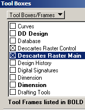 Then I want to merge it with a grayscale image that I have lower resolution but are a single image while keeping the color in front.
In this case I will use Microstation Descartes, which is an equivalent of AutoCAD Raster Design or what we knew as Overlay. If the Descartes tools are not visible, make "tools / toolboxes" and there the "Descartes Raster Control" panel is activated.
1. Cut the image based on the polygon.

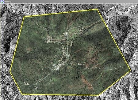
![]() Once I have the polygon, I use the command "corridor images", this asks for the cutting polygon, so I select it by clicking on the yellow shape.
Once I have the polygon, I use the command "corridor images", this asks for the cutting polygon, so I select it by clicking on the yellow shape.
Then when you make the second click, a screen appears asking me:
- which of the reference images I want to cut
- The destination route
- Image format
- If I want transparency in cut leftovers
- and output pixel size.
 By default it places the size of the pixels that the image has but I can change them.
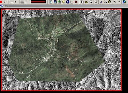
Then the message appears in the corner you are processing and the reference image appears at the end. In the result you can see that the color image has been cut, the rest transparent so that I can see the grayscale image behind.
2. Merge both images
![]() Now what I want is to make one of both images, so I make a shape of the area that I want to merge, and use the "merge images" button. It asks me the same as the previous command,
Now what I want is to make one of both images, so I make a shape of the area that I want to merge, and use the "merge images" button. It asks me the same as the previous command,  with the difference that in this case does not indicate each of the images but rather the "average" option to select both.
And ready gentlemen, see what a marvel, he has made an image with both.
Ah, to do this, it is not required to have a license from Descartes or Microstation, because the disc that Bentley sends if you enter your page in the Select CD option gives you 15 minutes ... what I have done has cost me 11.


I NEED HELP, I HAVE THE INSERTED PICTURE FROM AUTOCAD CIVIL 3D 2012, WITH CONNECT AND RASTER, THE ONLY THAT DOES NOT MAKE ME IS TO TRIM THE PART I DO NOT WANT TO GO, I DO NOT KNOW HOW TO DO IT, PLEASE I NEED HELP