Google Maps improves its performance
Google has released a new beta version of its map browser, with quite interesting tools. In this case, to activate it you have to execute the link New! to the right of the lab test symbol, and activate the options.
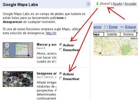
The warning is clear, they are only tests that are being done, so when they are finally released to the public, it could be that not all of them are included. Also if it becomes unstable you have to go back to the address:
http://maps.google.es/maps?ftr=0
Let's see that friends are brought back.

 Most practical, now the zoom can be done with a zoom window, as well as any CAD / GIS program. To do this, a button appears below the zoom bar.
The other attraction is a kind of isometric view, called rotating. I have no idea how they did it, but he's very stoned. In the example above it is the Convention Center where ESRI hosts its annual events, on Embarcadero Avenue in San Diego. See that they are shots of different hours, it shows in the shadow of the two towers, different from that of the curved building.
But these little things do not take away from the taste, the option to rotate from four angles and the zoom gives it a good utility. It has some similarity to Bird eye de Virtual Earth, But it is not the same, this is more like an isometric view and the one with more perspective, also seems more colorful, although there are not many places yet.
This option to rotate, is also in plant, being able to turn in angles of 90 degrees, keeping the names always in horizontal position.
Also added functions to the right button, where you can place the lat / long coordinate, or the alternative "here is", which displays the address and business at the selected point.
Other functionalities will have to be tested, such as smart zoom, which warns when a frame is being made that there is no content.
I leave them for you to try.