
Google Earth and its Creole technology
"Creole Technology" was the name as it was called a photogrammetric practice used in a locality of Colombia, made remote-controlled airplanes at a height of 800 meters.
According to this report, the accuracy achieved by these guys, exceeds the precision that Google Earth has and it seems they were the first Google accepted that have not been taken by manned or satellites.
Although it seemed a great novelty at the time, it is not a crazy idea, on the Interactive Mapping page there is a presentation that medium-term photogrammetry trends will be replaced by the use of small unmanned ships, contrary to the convention that We know that super-planned flights have been the norm ... which would reduce costs considerably.
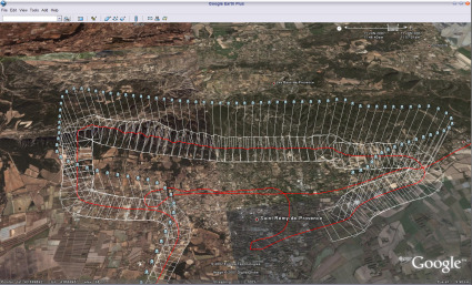
I understand that companies like Pict'Earth more or less that is their business, the top image shows some of the work that these guys do while in the lower part of the area planned in Santiago de Compostela.
According to the proposal of Marcos López Sánchez de Cartogalicia The Consortium of Santiago de Compostela used a practice to supervise a reconstruction work of the covering of the streets, with airplanes to remote control but more powerful than the exercise of the Colombians.
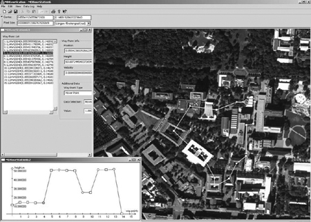
A 10 Mpixel camera with a fixed focus was placed, Topcom's PI-3000 software was used for orthorectification and the drone.
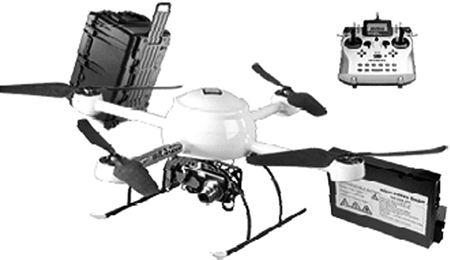
A (UAV) unmanned vehicle, true technological compendium equipped with gyroscopes, stabilizers, inertial systems, GPS, altitude controllers ... that is capable of flying up to 500 mts of altitude, emitting only 60 db at 3 meters and that will allow us Once a flight plan has been drawn up from either a Google Earth resident software tool or through a basic flight project development program, dump the coordinates obtained for each camera shot, flying and firing completely automatically. without the need for the intervention of an operator.
I recommend reading the full document of Interactive Mapping, because it shows a proposal not only under practical but technically acceptable criteria.
With regard to the work of Colombia, it is not necessary to underestimate its initiative because those who did the work are people dedicated to photogrammetry and this locality a couple of years ago won the Latin American award Digital Cities in the Small Population category.
What is funny is that the news says that the images exceeded the standards of precision and resolution that Google requires for the publication of its images ... until now we know that it has precision standards because from time to time we find splicing problems of up to 150 hehe meters.


