
Geoinformatics, latest edition 2009
This, which in my opinion is one of the best positioned magazines on the geospatial subject, has closed 2009 with a masterful seal; in its 7 editions it maintained a  Systematic review of FOSS and surveying equipment, in the latter (8 2009), generalizes in marked trends that are taking the geospatial aspect and the incidence of some non-free platforms in the middle.
Here I outline some of the main issues.
AutoDesk
Digital cities And how the acquisition of 3D Geo has given to LandXplorer features Google Earth style.
ESRI
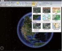 GIS for everyone, the new version of ArcGIS Explorer, now with more capabilities and as you can see ... The ribbon As an irreversible trend.
 - User Conference From ESRI / Europe
- GIS, Cadastre and land registry. This is a Interview with Nick Land, which tells us about ESRI's vision regarding the cadastre and how they see initiatives such as INSPIRE, Cadastre 2014 and WPLA.
Bentley
- There is an article about the Symposium Be Inspired
Team
 There are no specific reviews, but in advertising we leave expectations the total station Focus Spectra. You just have to see it to get your hopes up.
 - Also among the advertising excel SuperGeo with its GIS Learning CD And SuperGIS Image Server
The Cloud
This is the Central theme of this edition, in which brief editorial scratches the curiosity of an interesting article of 24-26 pages on the trends, scope and challenges that the concept of data management in the network is having and how the geospatial environment is collaborating significantly.
Sure 2010 will be a year of web application application reviews to give continuity to this topic, reinforce the topic articles as:
- Navteq wants you to reach your destination
- Geolocation and its progress in time.
There are other topics, it is worth to browse and download it in pdf for collection.
View the magazine


