
Connecting ArcGIS with Google Earth
We talked about how to achieve this before Connect Manifold with Google Earth and other virtual globes, now let's see how to do it with ArcGIS.
Some time ago many think that ESRI should implement this type of extensions, not only because it has the money but also because they are the felt needs of its users. Some have arisen for Download images, that its operation is not very legal for Google, and others like the one we are talking about today, whose characteristics and integration to ArcGIS are great, but it leaves us with the thoughts on what path ESRI takes in this regard.
The extension that allows ArcGIS to connect with virtual globes is Arc2Earth, the 1 version a few days ago had come out, although the greatest gains were in the ability to create kml content to easily and attractively upload to Google Earth, now it takes more strength to achieve an integration in both directions, to be able to import not only kml layers, but images from Google Earth, Virtual Earth, Yahoomaps and Ask.
Not bad for the users of ESRI that days ago we fight with this subject, since its attributes are quite robust and mainly because it is integrated like an extension of Arcmap

What you can export
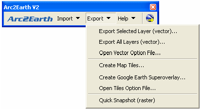
- Vector data
- Raster data
- Vector data as mosaics of images
- Option to export separate layers or associated documents
- New formats, kml, kmz, geoRSS (simple), GeoRSS (GML), GeoJson
- Export can be automated by configuring destination folders or urls
- You can add comments or copyrights to the created content
- Support for Kml 2.2
- Customizable lettering
What can it matter
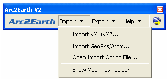
- Files kml, kmz, geoRSS (simple), GeoRSS (GML), AtomPub
- You can download any kml layer from a well-known url
- You can import individual kml files or whole folders
- Imports DTM models stored as grounds
- Add, update or delete imported layers as featureclass, for personal Geodatabase or stored in SDE
- Kml 2.2
- Some of these data can be exported in the form of mosaic indexes
The news is giving Return to the geospatial world By the news of the 2 version, although there are some doubts in the way:
Resource
Although the system only asks for ArcGIS 9.0 +, 2000 Windows and 1.1 .net framework, the dual core or 64 bit computers guarantee that your machine will not hang in the ifinito when you are working with large amounts of data.
Pricing
Arc2Earth Standard V2 - $ 199 USD
Arc2Earth Professional V2 - $ 399 USD
Arc2Earth Publisher V2 - $ 999 USD
Arc2Earth Enterprise V2 - $ 2500 USDSe Can download A trial version of 7 days that have export limits up to 500 attributes per layer, and 50 for import
For those who have 1 versions, the update costs 40% less, (until December of 2007)
There are also Other prices Lower for educational or non-commercial versions
They offer an 90 days warranty, if you are not satisfied with the proof you are given the silver
Several of these things make them manifold, for the same price ... although it's worth already invested a lot of silver in ESRI products.
Rights
There are still those who argue that Google does not want to cede right to the use of its services ... because it does not go through its API ...
It is not clear who they are selling, in some brochures claim to be almost brothers of Google, and others put the logo of ESRI as one of its products.
Limitants
The kml format continues to be a limitation for those of us who are used to seeing "pretty" maps, because to start with it only supports a projection, then the line styles cannot be displayed, the very complex shapes go crazy or overlap...
So even if we make our maps with improved aesthetic characteristics, finally the deployment will have to pass through a test and error filter.
What makes us pensive is if it is worth investing in an extension that ESRI is possibly thinking of offering for free, you guys thinking?
Updated:
There are other tools that perform similar functions:
- Mapserver - If you like super complicated.
- KmlCatalog - Pretty good, it does not take ArcGIS.
- Super Overlay - Reprojects data on the fly, does not handle vectors.
- Tiles 2 KML - Redesigned on the fly, it handles vectors in a slightly bizarre way.
- GPS Visualizer - Just to make overlays


ArcGIS can not do that, with StitchMaps it is possible to download images in mosaic and with a calibration file. Although not in tiff.
I would like to know if with arcgis or with another program you can download images from google earth in tif format so that you do not lose your resolution when downloading them from a higher height or if you can open google earth with arcgis9.3 thanks
I understand that this is an ArcGIS 9.3 functionality, according to the realease of this version.
http://www.esri.com/software/arcgis/arcgis10/index.html
I would like to upload a cartographic map of Argis9.2 to Google Eart how to do it.
Digital Globe has opened a free access to its images, although it is for a limited time, for users of Mapinfo, Autodesk map and ESRI
I think this app is not legal by GoogleEarth terms of use
http://www.google.com/earth/download/ge/agree.html