
Connect Manifold with Open Street Map
Some time ago I spoke to them that Manifold can connect to Google, Yahoo and Virtual Earth. Now the connector to link to Open Street Maps (OSM) has come out, which by the way has been developed in C # by a forum user called Jkelly.
The news appeared this week in the Manifold forum, Where both the .dll that allows the connection and the code were loaded so that someone could see how it was done and try to invent another smoke.
How to do it
In order to do this, DownloadFor now the Manifold forum, the dll to be placed in "files / Manifold System / Program", right in the place where the other connectors are put.
Then to load the layer is done with "File / image / link / manifold image services"
This allows a panel from where you can choose both Yahoo Maps, Google and Virtual Earth. Now you should be able to see the Virtual Earth layers as well:
- Mapnik
- Osmarender
- Cloudemade's cycle map

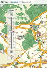
Result
At the end you have a linked image layer as we would see in OSM, and you can make zooms that can be stored in Cache if we decide to do so when loading the layer. It can also be unlinked, which would give us the option to choose the pixel size and save the coverage locally.

To see it on a map, just drag it into the view (map) and the system will warn that it is not in the same projection, in case it is not the same as OSM. So in the tab below, of the OSM layer that we have added to the display, we right-click and choose "use projection" and that's it.
It seems a good gesture, before one of the largest online vector databases, which as they say, stores more than 364 million items, the product of an extensive network of collaborators. Other products like Global Mapper y CadCorp They do.
Update: A library has also been uploaded to connect to Google Earth Terrain.


That good! An OS alternative… Works flawlessly… What a great job James K.