
Bentley Geospatial Administrator, toothache
 The Bentley Geospatial Administrator is one of the things that Bentley has not been able to make digestible and there have not been many exercises that explain its implementation in a real project. The objective of this tool, which is a complement to Bentley Map, is all the project construction that was previously done from within Geographics, such as:
- Create categories
- Create features
- Configure the connection to the database
- Define topological norms
- Formulate deployment scales
- Update tables
However, everything we knew about Geographics is of little use, since the functionality of the Geospatial Administrator is half taken for a ride. It has many capabilities, although quite hidden behind a right mouse button; which is expensive at the beginning.
Advantages of Geospatial Administrator.
Comparing how it was done with Geographics, here are some advantages:
- Figurines, I mean, before the majority of configurations lacked a graphic complement.
- Less programming, before doing this required getting into code from .ucf files and more.
- Actual features, now, symbology is not a CAD attribute, as before, but is totally associated with the attribute
- Scale, attributes can have scaling properties, thus deployed or hidden to configurable scales
- Commands associated with attributes, these are construction characteristics defined for the creation of objects, such as: when I create a street axis, the linestring command is immediately activated; this is called methods.
- The map has the data, it is possible to define how many of the attributes or data will be inside the xml of the map, so that the dgn contains data without needing to have connection to a database or complementary files.
- Direct link, when doing undo or redo, there is no inconsistency, as happened before because a link could create an object without reference to the database.
The tool itself is very robust, what happens is that it is complex to use. For the case, Bentley Hotels is an application built with Geospatial Administrator that additionally has a tutor that guides the initial conformation.
A friend approached me the other time, and he asked me if I could explain it ... in several posts I hope to do it, because now that I am looking at Bentley Map V8i and I see that they do not back down on the need to add wizzard to this puzzle. For now the post stays at a general level.
History and logic
The Geospatial Administrator arises from the adaptation of the xml technology in Microstation V8.5 known as XFM. As of Microstation V8.9, known as XM Geographics is renamed Bentley Map and it is the way it is still called in V8i.

Basically the projects with Bentley are structured in this line, as explained by our friend Martin:
Project (Project) ........................... .equivalent to school
Example: Cadastre Project
Categories (Categories) ............... .. equivalent to grades
Example: Categories: cadastral, road, forestry, hydrological ...
Attributes (Features) ......................... equivalent to materials
Example: street axis, estate polygon, bridge ...
Maps (Maps) ..................................... equivalent to students
Example: Map HJ44-2D.cat, forest zone B.for, 0311.hid
Before, all this was built from the Geographics side, now, all the configuration is separated from the Geospatial Administrator, leaving only the construction from the user side of Bentley Map. Such as opening the map x, displaying the list of categories, assigning attributes to it, theming it by, validating its topology, analyzing spatial layers ... etc.
So the Geospatial Administrator looks somewhat like a Geodatabase, only it contains nothing but the properties of the entire project.
Structure of the Geospatial Administrator

What we have is a tree structure of the different configurations carried out by a project, with the gain that now everything is done from here.
The configurations are grouped in:
- Features for all users in general (All users)
All these are general of the project.
All the categories are at this level and not at the particular user level.
Also at this level are the Topology and the configuration of the database to which this project is connected.
- The current user's workspace
These are already particular to the workspace known as user, or what we called before ucf ;. Unlike general parameters, it can contain:
-particular operations and methods for each feature. You can also define what features the user can have.
-Working Scales
-Archives, such as seed or shared libraries
-Macros and interface tools customized for the user.
All this was possible in Geographics by means of a .ucf file, which allowed to directly open Geographics in the defined project, with the necessary tools ... but it was made pure code.
- The dictionary of coordinate systems
Here are the different configurations for coordinate systems
- Spatial data sources
Here are defined configurations for accessing spatial databases via Oracle, as well as the Index which is the file containing a spatial index of all maps recorded in the database.
And so ?
 The project structure remains the same if the project is imported from Geographics but the structure changes if it is built from scratch:
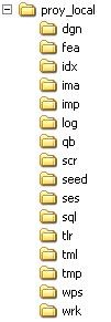
From here it is worth remembering some interesting folders:
- idx, is where the index file and the location is stored
- seed is where the seed file is stored
- sql, searches are saved here
- tlr, here are the topological layers
- wrk, working files
Unfortunately I do not know what to conclude at the end of this post, if someone buys Bentley Map and does not know how to use the Geospatial Administator ... it does not help. The Geospatial Administrator is too smoked for users who start in GIS.
But it's not a sin of Bentley, the toy is very robust, with .NET you can do wonders but like Geographics, difficult to ech
to walk without mega-helpThere are examples that come with the software, already assembled. Sin is little practical teaching on this; as being, a very good video in which a complete project is built and then fed, operated and exported to Geoweb Publisher. So that whoever is going to implement it knows which route to follow.
I know, it is a lot to ask but that is what we are, clients that we ask for. Ah, I forgot. In Spanish please.
Other Related Posts:


