
A good IMS site created with Manifold
Some days ago Explained how create a map service using Manifold GIS and create an ASP site by means of the template that comes by default and with a local server ... in 23 minutes.
This page of the city of Niagara Falls (Niagara Falls) On California Ontario is a good example of what you can do with a little creativity and code malice.
Tools menu.
 He is creative, they have added functionalities that are already in the template such as zoom, pan, measure, info, refresh ... What they did was use AJAX to create more attractive drop-down menus and icons although for public use.
The rest is pure creativity and taste applied to a css template.
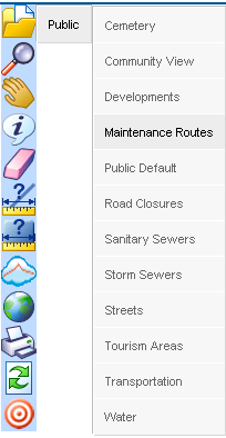
Layer Deployment
Before I had published the template that comes by default, which shows the layers that are available in the exported map. To call different maps, they have created a menu that calls those maps and thus displays the layers contained there. Bad vibes that by doing this it loses the extent of the previous deployment.
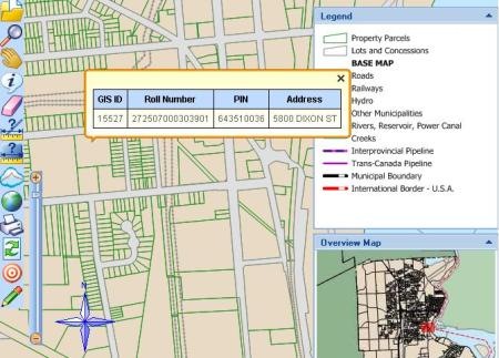
Data tabs
The panels on the right can be dragged and dropped, AJAX advantage, the rest is the simple template (search, layers, map overview and captions) with vertical display options. It is interesting that when a layer is shown, the layers are displayed in a contextual way with respect to that map (the map is a simile of the ArcMap mxd), and there they forced a button to refresh.
The rest, the northern watermark, graphic scale and a vertical approach bar that although misplaced works well.
Some functionalities leave us in doubt if they are applications on different images or layers, such as the orthophoto that can be displayed in black and white or in colors. With some Imagescript it should be possible to do on the same layer, just like the blurry mark when displaying information in a popup window. You also have the option to draw on the map, with some WFS-T you can create transactional maintenance services.
Cost? Manifold runtime, $ 100 on a server with IIS and tasteful css.
The site is constantly being updated, even now they have put the toolbar up, leaving the side end the option of legends and option to configure the order, visibility and opacity of the layers.


Thanks for the review on our site. A small correction about Niagara Falls though… we are in Ontario, Canada.